
Fichier:The Ancient Roads of Italy and Sicily nopng.svg

Fichier d’origine (Fichier SVG, nominalement de 1 201 × 1 340 pixels, taille : 245 kio)
Ce fichier et sa description proviennent de Wikimedia Commons.
Description
| Description |
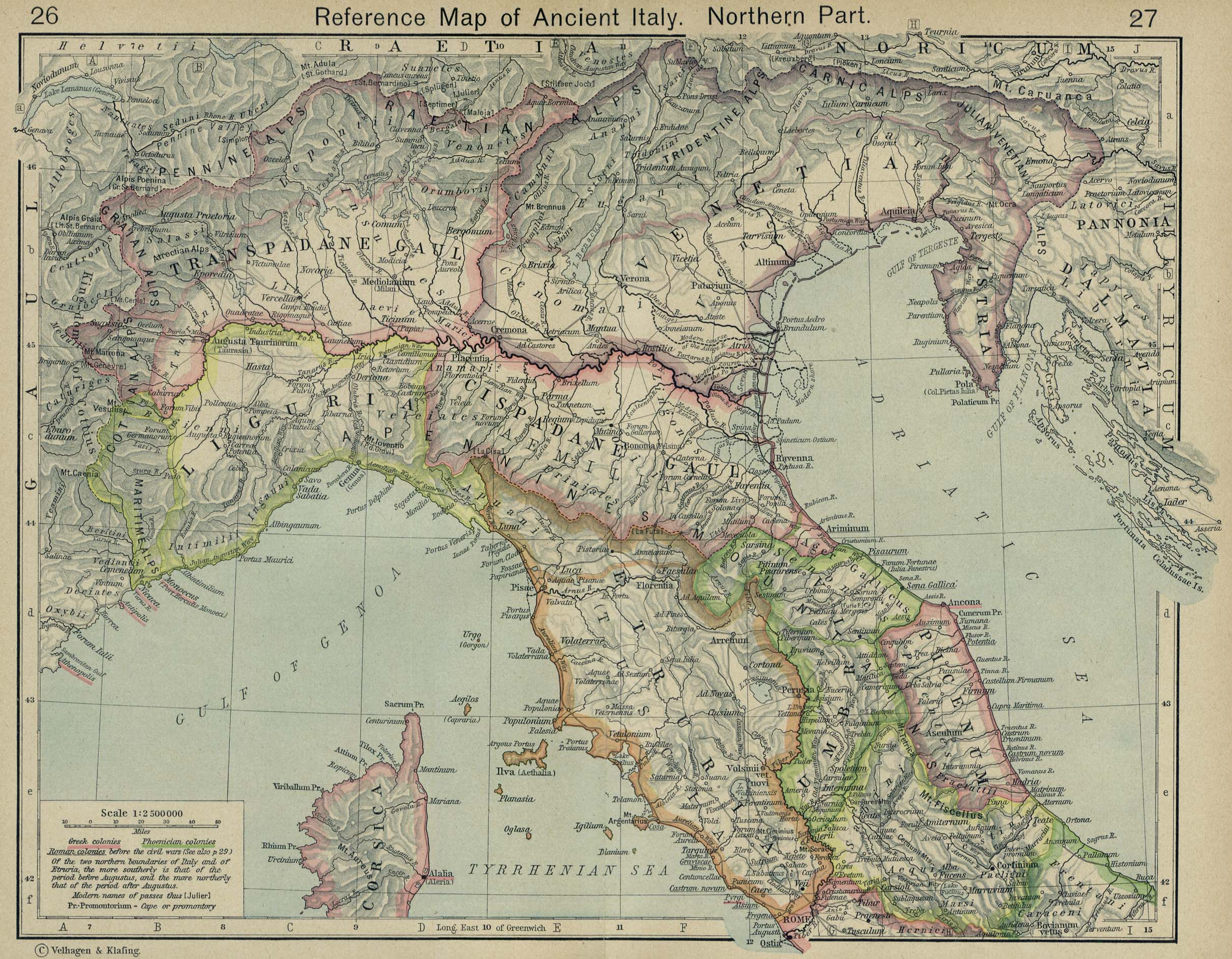
English: The major roads of Italy (going from Rome) are as follows, going clockwise from the left:
Corrections and additions are welcome! |
||
| Date | |||
| Source | Travail personnel | ||
| Auteur | Agamemnus | ||
| Autres versions |
|

Conditions d’utilisation
| Moi, propriétaire des droits d’auteur sur cette œuvre, la place dans le domaine public. Ceci s'applique dans le monde entier. Dans certains pays, ceci peut ne pas être possible ; dans ce cas : J’accorde à toute personne le droit d’utiliser cette œuvre dans n’importe quel but, sans aucune condition, sauf celles requises par la loi. |
Historique du fichier
Cliquer sur une date et heure pour voir le fichier tel qu'il était à ce moment-là.
| Date et heure | Vignette | Dimensions | Utilisateur | Commentaire | |
|---|---|---|---|---|---|
| actuel | 24 avril 2020 à 03:24 | | 1 201 × 1 340 (245 kio) | Ciaurlec | Changed alpha channel values to make it lighter |
| 20 février 2010 à 10:07 |  | 1 201 × 1 340 (245 kio) | Agamemnus | Bringing back a road that went missing. | |
| 13 février 2010 à 06:25 |  | 1 201 × 1 340 (239 kio) | Agamemnus | One more color change. | |
| 13 février 2010 à 06:19 |  | 1 201 × 1 340 (239 kio) | Agamemnus | Color change.. | |
| 13 février 2010 à 06:14 |  | 1 201 × 1 340 (239 kio) | Agamemnus | Minor road edit. | |
| 13 février 2010 à 06:04 |  | 1 201 × 1 340 (238 kio) | Agamemnus | Added a little compass showing north. Added a scale strip next to the compass. Changed Via Tiburtina color to dark purple. | |
| 9 février 2010 à 20:05 |  | 1 201 × 1 340 (230 kio) | Agamemnus | Moved the italy/sicily svg down so the roads could be seen again... | |
| 9 février 2010 à 10:18 |  | 1 201 × 1 340 (230 kio) | Agamemnus | Teh Sicily portion of the SVG is now more detailed. | |
| 9 février 2010 à 07:16 |  | 1 201 × 1 340 (220 kio) | Agamemnus | {{Information |Description={{en|1=The major roads of Italy (going from Rome) are as follows, going clockwise from the left: Green: Via Aurelia -> Via Aumelia Scaura -> Via Julia Augusta Bright green: Via Clodia Yellow: Via Cassia Blue: Via Flaminia Grey: |
Utilisation du fichier
La page suivante utilise ce fichier :
Usage global du fichier
Les autres wikis suivants utilisent ce fichier :
- Utilisation sur ca.wikipedia.org
- Utilisation sur en.wikipedia.org
- Utilisation sur la.wikipedia.org
- Utilisation sur sq.wikipedia.org
- Utilisation sur uk.wikipedia.org
- Utilisation sur zh.wikipedia.org