
Fichier:Emryetal2018 Africa Vs Depth Slices.pdf

Taille de cet aperçu JPG pour ce fichier PDF : 497 × 599 pixels. Autres résolutions : 199 × 240 pixels | 398 × 480 pixels | 637 × 768 pixels | 1 125 × 1 356 pixels.
Fichier d’origine (1 125 × 1 356 pixels, taille du fichier : 299 kio, type MIME : application/pdf)
Ce fichier et sa description proviennent de Wikimedia Commons.
Description
| Description |
English: Maps of four different depth slices of the Shear-velocity (Vs) model developed by Emry et al. 2018 (https://doi.org/10.17611/DP/EMCAFANTEM18, modified from the original using the IRIS DMC application https://doi.org/10.1785/0220120032). The forms of the zones with lower Vs (colors toward red) suggest the hotter structures in the Mantle. The distinguishing fourth map depicts a depth below the 410 km discontinuity where Vs steeps up (getting overall bluer) but still displays the signature of a plume at the substrate of the East African Rift. In the white box, the Vs vertical profile at 10°N, 40°E to illustrate the increase of velocity with depth and the effect of the 410 km discontinuity. |
| Date | |
| Source |
Composition of depth maps from the Earth model of Emry et al. 2018 |
| Auteur | Marcelo.silka |
- Other information
English: The original data is referenced in the legend (https://doi.org/10.17611/DP/EMCAFANTEM18 as well as the application of visualization (https://doi.org/10.1785/0220120032).
Conditions d’utilisation
Moi, en tant que détenteur des droits d’auteur sur cette œuvre, je la publie sous la licence suivante :
Ce fichier est sous la licence Creative Commons Attribution – Partage dans les Mêmes Conditions 4.0 International.
- Vous êtes libre :
- de partager – de copier, distribuer et transmettre cette œuvre
- d’adapter – de modifier cette œuvre
- Sous les conditions suivantes :
- paternité – Vous devez donner les informations appropriées concernant l'auteur, fournir un lien vers la licence et indiquer si des modifications ont été faites. Vous pouvez faire cela par tout moyen raisonnable, mais en aucune façon suggérant que l’auteur vous soutient ou approuve l’utilisation que vous en faites.
- partage à l’identique – Si vous modifiez, transformez, ou vous basez sur cette œuvre, vous devez distribuer votre contribution sous la même licence ou une licence compatible avec celle de l’original.

|
Ce fichier n'est pas catégorisé.
S'il vous plaît, aidez à améliorer ce fichier en ajoutant une ou plusieurs catégories, en relation avec d'autres fichiers (comment ?), et il sera donc plus facile à retrouver parmi tous les fichiers parallèles.
Merci d'avertir l'utilisateur avec : {{subst:Please link images|File:Emryetal2018 Africa Vs Depth Slices.pdf}} ~~~~ |
Historique du fichier
Cliquer sur une date et heure pour voir le fichier tel qu'il était à ce moment-là.
| Date et heure | Vignette | Dimensions | Utilisateur | Commentaire | |
|---|---|---|---|---|---|
| actuel | 12 mars 2019 à 04:24 | 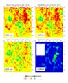 | 1 125 × 1 356 (299 kio) | Marcelo.silka | Scale and labels made bigger |
| 26 février 2019 à 20:56 | Aucune vignette | 0 × 0 (220 kio) | Marcelo.silka | {{subst:Upload marker added by en.wp UW}} {{Information |Description = {{en|Maps of four different depth slices of the Shear-velocity (Vs) model developed by Emry et al. 2018 (https://doi.org/10.17611/DP/EMCAFANTEM18, modified from the original using the IRIS DMC application https://doi.org/10.1785/0220120032). Zones of lower Vs (hot colors) indicate the forms for the hotter structures in the Mantle. The distinguishing fourth map depicts the depth below the 410 km discontinuity where Vs steep... |
Utilisation du fichier
La page suivante utilise ce fichier :
Usage global du fichier
Les autres wikis suivants utilisent ce fichier :
- Utilisation sur ar.wikipedia.org
- Utilisation sur en.wikipedia.org
- Utilisation sur sl.wikipedia.org