
Fichier:Zoufftgen rail crash map-fr.svg

Taille de cet aperçu PNG pour ce fichier SVG : 800 × 580 pixels. Autres résolutions : 320 × 232 pixels | 640 × 464 pixels | 1 024 × 743 pixels | 1 280 × 928 pixels | 2 560 × 1 856 pixels | 1 255 × 910 pixels.
Fichier d’origine (Fichier SVG, nominalement de 1 255 × 910 pixels, taille : 364 kio)
Ce fichier et sa description proviennent de Wikimedia Commons.
Description
| Description |
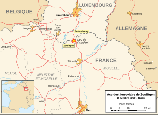
English: Map in French of the border region between France and Luxembourg showing the location of the rail crash occurred the 11th of October 2006 near the town of Zoufftgen, Moselle, France.
Français : Carte en français de la région de la frontière franco-luxembourgeoise montrant la localisation de l'accident ferroviaire survenu le 11 octobre 2006 près du village de Zoufftgen, Moselle, France. |
||
| Date | |||
| Source |
Own work Background reference map : Microsoft Encarta atlas (1999 edition) |
||
| Auteur | Eric Gaba (Sting - fr:Sting) | ||
| Autorisation (Réutilisation de ce fichier) |
|
Conditions d’utilisation
Moi, en tant que détenteur des droits d’auteur sur cette œuvre, je la publie sous la licence suivante :
Ce fichier est disponible selon les termes de la licence Creative Commons Attribution – Partage dans les Mêmes Conditions 2.5 Générique
- Vous êtes libre :
- de partager – de copier, distribuer et transmettre cette œuvre
- d’adapter – de modifier cette œuvre
- Sous les conditions suivantes :
- paternité – Vous devez donner les informations appropriées concernant l'auteur, fournir un lien vers la licence et indiquer si des modifications ont été faites. Vous pouvez faire cela par tout moyen raisonnable, mais en aucune façon suggérant que l’auteur vous soutient ou approuve l’utilisation que vous en faites.
- partage à l’identique – Si vous modifiez, transformez, ou vous basez sur cette œuvre, vous devez distribuer votre contribution sous la même licence ou une licence compatible avec celle de l’original.
Historique du fichier
Cliquer sur une date et heure pour voir le fichier tel qu'il était à ce moment-là.
| Date et heure | Vignette | Dimensions | Utilisateur | Commentaire | |
|---|---|---|---|---|---|
| actuel | 16 octobre 2006 à 18:34 | | 1 255 × 910 (364 kio) | Sting | Colour of departements names |
| 16 octobre 2006 à 18:17 |  | 1 255 × 910 (364 kio) | Sting | Departements border lines modification | |
| 16 octobre 2006 à 00:48 |  | 1 255 × 910 (364 kio) | Sting | Hidden / deleted roads (Inkscape bug) | |
| 16 octobre 2006 à 00:40 |  | 1 255 × 910 (411 kio) | Sting | Suppression roads : more comprehensible | |
| 15 octobre 2006 à 23:26 |  | 1 255 × 910 (411 kio) | Sting | Same modification | |
| 15 octobre 2006 à 22:52 |  | 1 255 × 910 (411 kio) | Sting | Railroads lines larger | |
| 15 octobre 2006 à 21:44 |  | 1 255 × 910 (411 kio) | Sting | {{Information |Description=Map in French of the border region between France and Luxembourg showing the location of the rail crash occurred the 11th of October 2006 near the town of Zoufftgen, Moselle, Fra |
Utilisation du fichier
Les 2 pages suivantes utilisent ce fichier :
Usage global du fichier
Les autres wikis suivants utilisent ce fichier :
- Utilisation sur en.wikipedia.org
- Utilisation sur fr.wikinews.org
- Utilisation sur lb.wikipedia.org
- Utilisation sur pl.wikipedia.org