
Fichier:V-1 1944 - Typical Ski Site.jpg
Taille de cet aperçu : 800 × 474 pixels. Autres résolutions : 320 × 190 pixels | 640 × 379 pixels | 1 024 × 607 pixels | 1 280 × 759 pixels | 2 560 × 1 518 pixels | 3 645 × 2 161 pixels.
Fichier d’origine (3 645 × 2 161 pixels, taille du fichier : 2,09 Mio, type MIME : image/jpeg)
Ce fichier et sa description proviennent de Wikimedia Commons.
| Description |
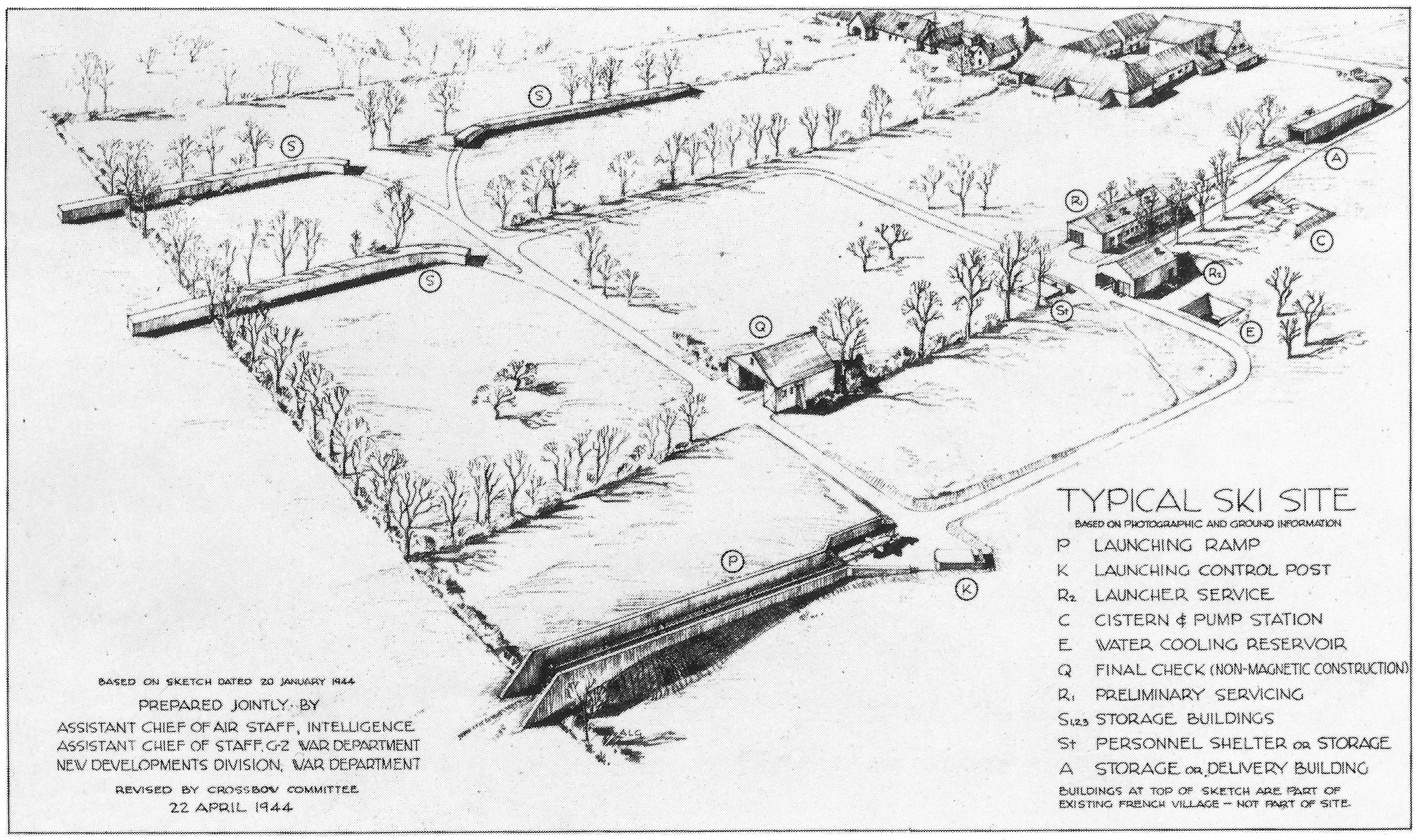
Diagram of World War II launch facility for the V-1 flying bomb
Deutsch: Fieseler Fi 103
English: V-1 flying bomb (facilities)
Français : V1 (missile)
|
||||||
| Date | |||||||
| Source | United States Air Force[1] | ||||||
| Auteur | (see image) | ||||||
| Autorisation (Réutilisation de ce fichier) |
|
||||||

- References
- ↑ a b Bauer, Eddy (original text) (1966) [1972] Illustrated World War II Encyclopedia, H. S. Stuttman Inc., pp. p2,059,2,068 (Vol 15) ISBN : 0-87475-520-4. « [Source:](United States Air Force) »
- ↑ Zaloga, Steven J.; Johnson, Hugh & Taylor, Chris (Illustrations) (2008) [2007] German V-Weapon Sites 1943-45, Fortress Study Group (72), Category:New York : Osprey Publishing Ltd, p. 24 ISBN : 978 184603 247 9.
- ↑ Dupuy, Trevor Nevitt (1963) Volume 7, The Air War in the West: June 1941--April 1945, Category:New York : Franklin Watts, Inc, p. 52 Accès 3 décembre 2009. « [Source:]U.S. AIR FORCE PHOTO »
Historique du fichier
Cliquer sur une date et heure pour voir le fichier tel qu'il était à ce moment-là.
| Date et heure | Vignette | Dimensions | Utilisateur | Commentaire | |
|---|---|---|---|---|---|
| actuel | 3 janvier 2009 à 01:47 | | 3 645 × 2 161 (2,09 Mio) | Mugs2109 | {{Information |Description={{en|1=Diagram of World War II launch facility for the V-1 flying bomb}} |Source=War Department<ref name=Bauer>{{cite book |last=Bauer |first=Eddy (original text) |origyear=1972|year=1966 |title=Illustrated World War II |
Utilisation du fichier
La page suivante utilise ce fichier :
Usage global du fichier
Les autres wikis suivants utilisent ce fichier :
- Utilisation sur en.wikipedia.org
- Utilisation sur www.wikidata.org