
Fichier:USACE Jim Woodruff Lock and Dam.jpg

Taille de cet aperçu : 800 × 533 pixels. Autres résolutions : 320 × 213 pixels | 640 × 426 pixels | 1 024 × 682 pixels | 1 500 × 999 pixels.
Fichier d’origine (1 500 × 999 pixels, taille du fichier : 478 kio, type MIME : image/jpeg)
Ce fichier et sa description proviennent de Wikimedia Commons.
| Description |
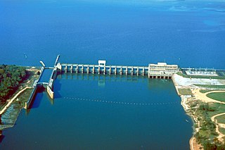
English: Aerial view of Jim Woodruff Lock and Dam, impounding Lake Seminole on the Chattahoochee River and Flint River confluence. The Apalachicola River flows out of the dam.
|
|||
| Lieu | Chattachoochee, Florida, USA 30°42′31.35″N 84°51′47.85″W / 30.7087083°N 84.8632917°W |
|||
| Date | ||||
| Source |
U.S. Army Corps of Engineers Digital Visual Library Image page Image description page Digital Visual Library home page |
|||
| Auteur | U.S. Army Corps of Engineers, photographer not specified or unknown | |||
| Autorisation (Réutilisation de ce fichier) |
|
Historique du fichier
Cliquer sur une date et heure pour voir le fichier tel qu'il était à ce moment-là.
| Date et heure | Vignette | Dimensions | Utilisateur | Commentaire | |
|---|---|---|---|---|---|
| actuel | 18 avril 2007 à 06:31 | | 1 500 × 999 (478 kio) | DanMS | {{Information2 | Description = {{en|Aerial view of Jim Woodruff Lock and Dam, impounding Lake Seminole on the Chattahoochee and Flint Rivers. The dam spans the Florida–Georgia border, and also the border between Jackson and Gadsden Counties in Florid |
Utilisation du fichier
Les 2 pages suivantes utilisent ce fichier :
Usage global du fichier
Les autres wikis suivants utilisent ce fichier :
- Utilisation sur arz.wikipedia.org
- Utilisation sur be.wikipedia.org
- Utilisation sur bn.wikipedia.org
- Utilisation sur ca.wikipedia.org
- Utilisation sur ceb.wikipedia.org
- Utilisation sur da.wikipedia.org
- Utilisation sur de.wikipedia.org
- Utilisation sur en.wikipedia.org
- Utilisation sur es.wikipedia.org
- Utilisation sur no.wikipedia.org
- Utilisation sur ru.wikipedia.org
- Utilisation sur sr.wikipedia.org
- Utilisation sur www.wikidata.org