
Fichier:Thomas Circle - Washington, D.C..jpg

Fichier d’origine (5 672 × 3 944 pixels, taille du fichier : 4,97 Mio, type MIME : image/jpeg)
Ce fichier et sa description proviennent de Wikimedia Commons.
Description
| Description |
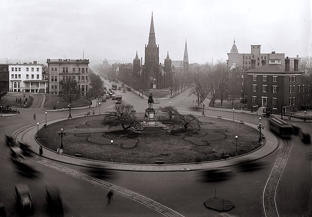
Looking north past Thomas Circle in Washington, D.C. as viewed from the Portland Flats (demolished; built in 1880 and designed by Adolf Cluss; city's first apartment building). The traffic circle is located at the junction of 14th Street (visible on the lower right and center left), Massachusetts Avenue (right and left sides), Vermont Avenue (lower left and center right), and M Street (bottom right and bottom left), NW. The equestrian statue seen in this image was erected in 1879 and honors General George Henry Thomas. The streetcar lines wrapping around the Circle on 14th Street were installed in the 1890s, but no longer exist. The homes visible on either side of the Circle have been demolished. National City Christian Church, designed by John Russell Pope in 1930, now stands on the Circle's west side and is a contributing property to the Greater Fourteenth Street Historic District. The Wylie House, seen on the right, was demolished in 1947 and replaced with the nine-story Washington Plaza Hotel designed by Morris Lapidus. The taller church seen directly across the Circle is Luther Place Memorial Church (originally known as Memorial Evangelical Lutheran Church), built in 1873 and listed on the National Register of Historic Places. A statue honoring Martin Luther is located in front of the church. It was a gift from the German emperor in 1884 and is a replica of the Martin Luther statue in Worms, Germany. Directly behind Luther Place is Mount Olivet Lutheran Church, a contributing property to the Logan Circle Historic District. The building was constructed in 1884 and originally home to the Vermont Avenue Christian Church (original name for the National City Christian Church). Mount Olivet purchased the property in 1953. The two remaining landmarks that can be seen in this image include Vermont Avenue Baptist Church (look NE on Vermont; the steeple is visible) and John Wesley AME Zion Church (look north on 14th Street; the steeple is also visible). Both buildings are contributing properties to the Greater Fourteenth Street Historic District. |
||
| Date | |||
| Source |
|
||
| Auteur | National Photo Company | ||
| Autres versions |
Œuvres dérivées de ce fichier : |


Conditions d’utilisation
Ce média est dans le domaine public des États-Unis d’Amérique car son auteur est l’administration américaine comme précisé dans le code fédéral au Titre 17, Chapitre 1, Section 105. Pour en savoir plus : droit d’auteur.
Attention : Ceci ne concerne que le travail du Gouvernement Fédéral et pas celui des États, ou d’une autre subdivision géographique ou politique du pays.
|
 | |
| Ce fichier a été identifié comme étant exempt de restrictions connues liées au droit d’auteur, y compris tous les droits connexes et voisins. | ||
Historique du fichier
Cliquer sur une date et heure pour voir le fichier tel qu'il était à ce moment-là.
| Date et heure | Vignette | Dimensions | Utilisateur | Commentaire | |
|---|---|---|---|---|---|
| actuel | 5 février 2009 à 13:21 | | 5 672 × 3 944 (4,97 Mio) | APK | {{Information |Description=Looking north past Thomas Circle in Washington, D.C. as viewed from the Portland Flats (demolished; built in 1880 and designed by Adolf Cluss; city's first apartment building). The traffic circle is located at the junction of 14 |
Utilisation du fichier
La page suivante utilise ce fichier :
Usage global du fichier
Les autres wikis suivants utilisent ce fichier :
- Utilisation sur ceb.wikipedia.org
- Utilisation sur en.wikipedia.org
- Utilisation sur tl.wikipedia.org
- Utilisation sur www.wikidata.org