
Fichier:Start Point - geograph.org.uk - 1335940.jpg
Pas de plus haute résolution disponible.
Start_Point_-_geograph.org.uk_-_1335940.jpg (640 × 480 pixels, taille du fichier : 237 kio, type MIME : image/jpeg)
Ce fichier et sa description proviennent de Wikimedia Commons.
Description
| Description |
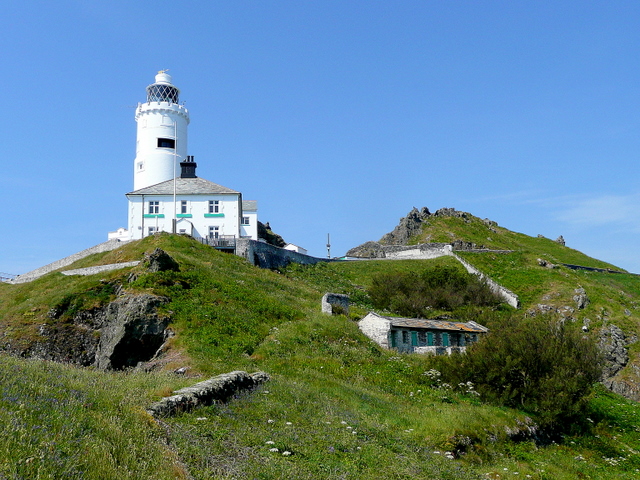
English: Start Point The lighthouse and cottage is viewed from SX8337 to the east. The building lower down to the right is a block of old pig sties dating back to when the lighthouse keepers tended their own smallholding on the sreep northern side of the headland.
Above and behind the scene are the schist outcrops of The Warren which forms the spine of the peninsula. |
| Date | |
| Source | From geograph.org.uk |
| Auteur | Jonathan Billinger |
| Attribution (imposé par la licence) | Jonathan Billinger / Start Point / |
| Lieu de la prise de vue | | Voir cet endroit et d’autres images sur : OpenStreetMap |
|---|
_heading:247.00&language=fr)
| Position de l'objet | | Voir cet endroit et d’autres images sur : OpenStreetMap |
|---|
_heading:247.00&language=fr)
Conditions d’utilisation

|
Cette image provient de la collection du projet Geograph British Isles. Pour obtenir les coordonnées du photographe, veuillez consulter cette page de description de l'image sur le site du projet. Les droits d'auteurs sur cette image sont détenus par Jonathan Billinger ; l'image est placée sous une licence Creative Commons avec mention de paternité et partage à l'identique (CC-By-SA) en version 2.0.
|
Ce fichier est disponible selon les termes de la licence Creative Commons Attribution – Partage dans les Mêmes Conditions 2.0 Générique
Attribution: Jonathan Billinger
- Vous êtes libre :
- de partager – de copier, distribuer et transmettre cette œuvre
- d’adapter – de modifier cette œuvre
- Sous les conditions suivantes :
- paternité – Vous devez donner les informations appropriées concernant l'auteur, fournir un lien vers la licence et indiquer si des modifications ont été faites. Vous pouvez faire cela par tout moyen raisonnable, mais en aucune façon suggérant que l’auteur vous soutient ou approuve l’utilisation que vous en faites.
- partage à l’identique – Si vous modifiez, transformez, ou vous basez sur cette œuvre, vous devez distribuer votre contribution sous la même licence ou une licence compatible avec celle de l’original.
{
Historique du fichier
Cliquer sur une date et heure pour voir le fichier tel qu'il était à ce moment-là.
| Date et heure | Vignette | Dimensions | Utilisateur | Commentaire | |
|---|---|---|---|---|---|
| actuel | 28 février 2011 à 04:25 | | 640 × 480 (237 kio) | GeographBot | == {{int:filedesc}} == {{Information |description={{en|1=Start Point The lighthouse and cottage is viewed from SX8337 to the east. The building lower down to the right is a block of old pig sties dating back to when the lighthouse keepers tended their |
Utilisation du fichier
La page suivante utilise ce fichier :
Usage global du fichier
Les autres wikis suivants utilisent ce fichier :
- Utilisation sur pl.wikipedia.org
- Utilisation sur www.wikidata.org