
Fichier:River Parrett map.png

Taille de cet aperçu : 450 × 599 pixels. Autres résolutions : 180 × 240 pixels | 361 × 480 pixels | 765 × 1 018 pixels.
Fichier d’origine (765 × 1 018 pixels, taille du fichier : 585 kio, type MIME : image/png)
Ce fichier et sa description proviennent de Wikimedia Commons.
| Description |
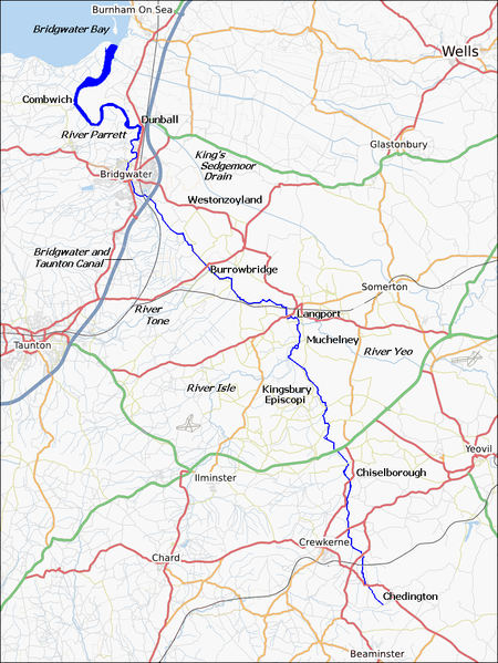
English: Map of the River Parrett, in Somerset, England. |
| Date | |
| Source | http://www.openstreetmap.org/ with some labels added by Ruhrfisch (talk) |
| Auteur | http://www.openstreetmap.org/, Ruhrfisch (talk) |
| Autorisation (Réutilisation de ce fichier) |
The Open Street Map Project content is licensed under the Creative Commons Attribution-Share Alike 2.0 Generic |
| Description |
Cette carte a été créée à partir des données du projet OpenStreetMap. Cette carte est peut-être incomplète et peut contenir des erreurs. Ne vous fiez pas uniquement à elle pour vos déplacements. |
| Date | (voir l'historique du fichier) |
| Source | Il existe probablement une [page https://wiki.openstreetmap.org/wiki/River+Parrett sur le wiki d'OpenStreetMap sur ce sujet : River Parrett] |
| Créé par |
contributeurs d'OpenStreetMap |
| Autorisation (Réutilisation de ce fichier) |
Les données et cartes d'OpenStreetMap sont publiées sous licence Creative Commons Attribution-ShareAlike 2.0 license (CC-BY-SA 2.0). Ce fichier est disponible selon les termes de la licence Creative Commons Attribution – Partage dans les Mêmes Conditions 2.0 Générique
|
| Géoréférencement | Si c'est inapproprié, définissez warp_status = skip pour masquer. |
Historique du fichier
Cliquer sur une date et heure pour voir le fichier tel qu'il était à ce moment-là.
| Date et heure | Vignette | Dimensions | Utilisateur | Commentaire | |
|---|---|---|---|---|---|
| actuel | 13 février 2010 à 04:58 | | 765 × 1 018 (585 kio) | Ruhrfisch | Cropped map to make it narrower, so it will diplay more detail at the same fixed width |
| 10 février 2010 à 20:33 |  | 884 × 1 018 (676 kio) | Ruhrfisch | Fix white square in top left corner - D'oh! | |
| 10 février 2010 à 20:31 |  | 884 × 1 018 (676 kio) | Ruhrfisch | Add Bridgwater and Taunton Canal | |
| 10 février 2010 à 19:19 |  | 884 × 1 018 (676 kio) | Ruhrfisch | Add more labels - two towns, several rivers | |
| 9 février 2010 à 18:07 |  | 884 × 1 018 (675 kio) | Ruhrfisch | Made course of river a more prominent dark blue | |
| 8 février 2010 à 21:02 |  | 884 × 1 018 (677 kio) | Ruhrfisch | {{Information |Description={{en|Map of the {{w|River Parrett}}, in Somerset, England.}} |Source= http://www.openstreetmap.org/ |Date= 2010-02 |Author= http://www.openstreetmap.org/, ~~~ |Permission= The Open Street Map Project content is licensed under th |
Utilisation du fichier
La page suivante utilise ce fichier :
Usage global du fichier
Les autres wikis suivants utilisent ce fichier :
- Utilisation sur en.wikipedia.org
- Utilisation sur simple.wikipedia.org
- Utilisation sur sr.wikipedia.org