
Fichier:Rand, McNally and Co. Map of the Houston and Texas Central Railway 1880 UTA.jpg

Fichier d’origine (8 476 × 8 528 pixels, taille du fichier : 11,04 Mio, type MIME : image/jpeg)
Ce fichier et sa description proviennent de Wikimedia Commons.
Description
| Titre |
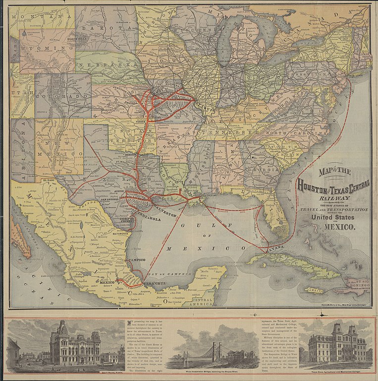
English: Map of the Houston and Texas Central Railway. The New Avenue of Travel and Transportation Between the United States and Mexico |
||||||||||||||||||||||||||
| Description |
English: This folding railroad promotional brochure map is a fine example of a late nineteenth-century American railway map by one of the most important American railway mapmakers and publishers still in business today: Rand, McNally and Company of Chicago. Established in 1858 as a printing company, by 1873 the firm was known for its railroad related work and had also opened a map department where they advertised "all kinds of Relief Plate Engraving [cerography or wax engraving]". The heavy lines with evenly spaced dots emphasize the main railroad lines, and each dot represents a "whistle-stop" or station where the train would let off and take on passengers and freight. This was, and still is, a characteristic feature of many railroad and subway maps which simplify, exaggerate, and distort distances, area, and direction in order to convey key information. Although the Houston and Texas Central Railway is the central focus of the map, it also delineates the railroad's integration with New York shipping and railroad magnate Charles W. Morgan's steamship lines, the Texas and New Orleans, the Galveston, Harrisburg and San Antonio, the Missouri, Kansas and Texas, and other railroads.
|
||||||||||||||||||||||||||
| Date | |||||||||||||||||||||||||||
| Source | UTA Libraries Cartographic Connections: carte / texte | ||||||||||||||||||||||||||
| Créé par |
Houston and Texas Central Railway Rand, McNally & Company |
||||||||||||||||||||||||||
| Attribution de l’acquisition |
English: The University of Texas at Arlington Libraries Special Collections |
||||||||||||||||||||||||||
| Données géotemporelles | |||||||||||||||||||||||||||
| Lieu |
États-Unis Mexique |
||||||||||||||||||||||||||
| Géoréférencement | Si c'est inapproprié, définissez warp_status = skip pour masquer. | ||||||||||||||||||||||||||
| Données bibliographiques | |||||||||||||||||||||||||||
| Lieu de publication | Chicago | ||||||||||||||||||||||||||
| Imprimé par |
Rand, McNally and Company (for the Houston and Texas Central Railway) |
||||||||||||||||||||||||||
| Données d'archives | |||||||||||||||||||||||||||
| Collection |
|
||||||||||||||||||||||||||
| Dimensions | hauteur : 50 cm ; largeur : 50 cm | ||||||||||||||||||||||||||
| Technique / matériaux | cerograph en couleurs | ||||||||||||||||||||||||||
| artwork-references |
Modelski Railroad Maps of North America, pp. xvi-xx Vivian Elizabeth Smyrl. Waco Suspension Bridge. Handbook of Texas Online. Retrieved on April 2, 2022. Buisseret, David; Richard Francaviglia, Gerald Saxon, and Jack W. Graves, Jr. (2009) Historic Texas From the Air, Austin : University of Texas Press, pp. 112−113 Baughman, James P. (1968) Charles Morgan and the Development of Southern Transportation, Nashville : Vanderbilt University Press Francaviglia, Richard V. (1998) From Sail to Steam: Four Centuries of Texas Maritime History, 1500-1900, Austin : University of Texas Press, p. 128ff |
||||||||||||||||||||||||||
| Autres versions | |||||||||||||||||||||||||||
.jpg)
.jpg)
.jpg)
Conditions d’utilisation

|
This file was provided to Wikimedia Commons by the University of Texas at Arlington Libraries as part of a cooperation project. The University of Texas at Arlington Libraries is part of the University of Texas at Arlington, a public research university located in Arlington, Texas.
|
Cette œuvre a été publiée avant le 1er janvier 1929. Son auteur n'étant pas connu, cette œuvre est anonyme. Elle est donc dans le domaine public aux États-Unis, ainsi que dans les pays où la durée du droit d'auteur pour les œuvres anonymes est inférieure à 95 ans après la date de première publication.
|
Historique du fichier
Cliquer sur une date et heure pour voir le fichier tel qu'il était à ce moment-là.
| Date et heure | Vignette | Dimensions | Utilisateur | Commentaire | |
|---|---|---|---|---|---|
| actuel | 2 avril 2022 à 23:37 | | 8 476 × 8 528 (11,04 Mio) | Michael Barera | == {{int:filedesc}} == {{Map |title = {{en|'''''Map of the Houston and Texas Central Railway. The New Avenue of Travel and Transportation Between the United States and Mexico'''''}} |description = {{en|This folding railroad promotional brochure map is a fine example of a late nineteenth-century American railway map by one of the most important American railway mapmakers and publishers still in business today: Rand, McNally and Company of Chicago. Established in 1858 as a p... |
Utilisation du fichier
La page suivante utilise ce fichier :
Usage global du fichier
Les autres wikis suivants utilisent ce fichier :
- Utilisation sur en.wikipedia.org
- Utilisation sur it.wikipedia.org