
Fichier:Polandmap cia gdansk.png
Pas de plus haute résolution disponible.
Polandmap_cia_gdansk.png (246 × 400 pixels, taille du fichier : 20 kio, type MIME : image/png)
Ce fichier et sa description proviennent de Wikimedia Commons.
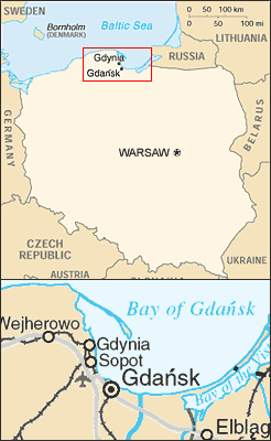
Map of Poland showing relative position of Gdansk, Gdynia and Sopot.
- Mapping from CIA World Factbook and United Nations map of Poland - see http://www.un.org/Depts/Cartographic/map/profile/poland.pdf
- Composited by ChrisO, Feb 18, 2004
CIA World Factbook
This image is a map or flag taken and/or modified from the Central Intelligence Agency's World Factbook. Under United States copyright law, all information and images from the World Factbook are in the public domain.
Cette image est dans le domaine public parce que son contenu provient du World Factbook, édité par la Central Intelligence Agency des États-Unis d’Amérique.
|
 |
Historique du fichier
Cliquer sur une date et heure pour voir le fichier tel qu'il était à ce moment-là.
| Date et heure | Vignette | Dimensions | Utilisateur | Commentaire | |
|---|---|---|---|---|---|
| actuel | 9 juillet 2005 à 19:13 | | 246 × 400 (20 kio) | Michiel1972 | Map of Poland showing relative position of Gdansk, Gdynia and Sopot. * Mapping from CIA World Factbook and United Nations map of Poland - see http://www.un.org/Depts/Cartographic/map/profile/poland.pdf * Composited by ChrisO, Feb 18, 2004 CIA W |
Utilisation du fichier
La page suivante utilise ce fichier :
Usage global du fichier
Les autres wikis suivants utilisent ce fichier :
- Utilisation sur en.wikipedia.org
- Utilisation sur fi.wikipedia.org
- Utilisation sur incubator.wikimedia.org
- Utilisation sur th.wikipedia.org