
Fichier:Lake Erie Islands Map.png

Taille de cet aperçu : 800 × 561 pixels. Autres résolutions : 320 × 225 pixels | 640 × 449 pixels | 1 024 × 719 pixels | 1 160 × 814 pixels.
Fichier d’origine (1 160 × 814 pixels, taille du fichier : 47 kio, type MIME : image/png)
Ce fichier et sa description proviennent de Wikimedia Commons.
Description
| Description |
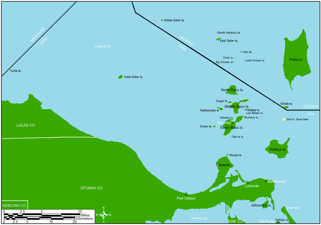
English: Map showing a majority of the Lake Erie islands that lie between Toledo and Cleveland.
|
| Date | |
| Source | Drawn in ArcMap and Microsoft Paint |
| Auteur | Frank12 |
Conditions d’utilisation
Frank12 sur Wikipédia anglais, en tant que détenteur des droits d’auteur sur cette œuvre, la publie sous les licences suivantes :

|
Vous avez la permission de copier, distribuer et modifier ce document selon les termes de la GNU Free Documentation License version 1.2 ou toute version ultérieure publiée par la Free Software Foundation, sans sections inaltérables, sans texte de première page de couverture et sans texte de dernière page de couverture. Un exemplaire de la licence est inclus dans la section intitulée GNU Free Documentation License. |
Ce fichier est disponible selon les termes de la licence Creative Commons Attribution – Partage dans les Mêmes Conditions 3.0 (non transposée).
Attribution: Frank12 sur Wikipédia anglais
- Vous êtes libre :
- de partager – de copier, distribuer et transmettre cette œuvre
- d’adapter – de modifier cette œuvre
- Sous les conditions suivantes :
- paternité – Vous devez donner les informations appropriées concernant l'auteur, fournir un lien vers la licence et indiquer si des modifications ont été faites. Vous pouvez faire cela par tout moyen raisonnable, mais en aucune façon suggérant que l’auteur vous soutient ou approuve l’utilisation que vous en faites.
- partage à l’identique – Si vous modifiez, transformez, ou vous basez sur cette œuvre, vous devez distribuer votre contribution sous la même licence ou une licence compatible avec celle de l’original.
Vous pouvez choisir l’une de ces licences.
Journal des téléversements d’origine
La page de description originale était ici. Tous les noms d'utilisateur qui suivent se rapportent à en.wikipedia.
| Date et heure | Dimensions | Utilisateur | Commentaire |
|---|---|---|---|
| 2014-03-19 11:41 | 1160×814× (65335 bytes) | Frank12 | Added Kafralu Island and labeled Sandusky County. |
| 2014-03-10 12:14 | 1160×814× (63558 bytes) | Frank12 | Added Put-in-Bay, a scale, and a north arrow. |
| 2014-03-10 12:10 | 1160×814× (54384 bytes) | Frank12 | Area expanded to include Turtle Island. |
| 2014-03-06 15:02 | 1232×873× (56674 bytes) | Frank12 | Labeled Catawba Island, Lakeside, and Marblehead. |
| 2014-03-06 14:41 | 1232×873× (54446 bytes) | Frank12 | Uploading a self-made file using [[Wikipedia:File_Upload_Wizard|File Upload Wizard]] |
Historique du fichier
Cliquer sur une date et heure pour voir le fichier tel qu'il était à ce moment-là.
| Date et heure | Vignette | Dimensions | Utilisateur | Commentaire | |
|---|---|---|---|---|---|
| actuel | 12 juillet 2018 à 14:46 | | 1 160 × 814 (47 kio) | Frank12 | Adjusted scale bar to show measurements in both Miles and Kilometers, and added a North Star with the four cardinal directions. |
| 3 juin 2016 à 06:07 |  | 1 160 × 814 (64 kio) | OgreBot | (BOT): Reverting to most recent version before archival | |
| 3 juin 2016 à 06:07 |  | 1 160 × 814 (62 kio) | OgreBot | (BOT): Uploading old version of file from en.wikipedia; originally uploaded on 2014-03-10 12:14:45 by Frank12 | |
| 3 juin 2016 à 06:07 |  | 1 160 × 814 (53 kio) | OgreBot | (BOT): Uploading old version of file from en.wikipedia; originally uploaded on 2014-03-10 12:10:33 by Frank12 | |
| 3 juin 2016 à 06:07 |  | 1 232 × 873 (55 kio) | OgreBot | (BOT): Uploading old version of file from en.wikipedia; originally uploaded on 2014-03-06 15:02:58 by Frank12 | |
| 3 juin 2016 à 06:06 |  | 1 232 × 873 (53 kio) | OgreBot | (BOT): Uploading old version of file from en.wikipedia; originally uploaded on 2014-03-06 14:41:48 by Frank12 | |
| 25 avril 2016 à 06:29 |  | 1 160 × 814 (64 kio) | FastilyClone | Transferred from enwp |
Utilisation du fichier
Les 9 pages suivantes utilisent ce fichier :
Usage global du fichier
Les autres wikis suivants utilisent ce fichier :
- Utilisation sur en.wikipedia.org
- Utilisation sur ru.wikipedia.org