
Fichier:Kirk Braddan Old Church - geograph.org.uk - 24358.jpg
Pas de plus haute résolution disponible.
Kirk_Braddan_Old_Church_-_geograph.org.uk_-_24358.jpg (640 × 427 pixels, taille du fichier : 92 kio, type MIME : image/jpeg)
Ce fichier et sa description proviennent de Wikimedia Commons.
Description
| Description |
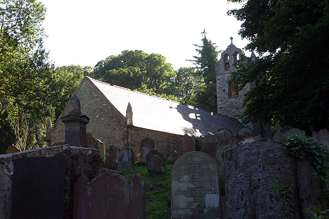
English: Kirk Braddan Old Church. The mother church of Douglas set in a beautiful wooded valley by the River Dhoo. The churchyard is full of Georgian head-stones and dominated by an obelisk designed by Steuart to Lord Henry Murray. Tower, 1773. Interior high pews, galleries, clear glass and monuments on walls.[JB]
Built 1773 following presentations that the roof and gable of the previous church were unsafe and also after complaints that the previous church was too small. The received wisdom is that the old church was demolished and the new built from the reclaimed rubble though with quoins of Foxdale granite. However recent surveys by Mr F. Cowin have convinced him that although the east end was demolished and rebuilt and the tower added, the remaining walls are mostly the original dating from the twelfth century. Following the precedent of St Marks (b 1772) the four corners were marked by pinnacles. Unlike many other island churches it was probably never whitewashed. |
| Date | |
| Source | From geograph.org.uk |
| Auteur | Andy Stephenson |
| Attribution (imposé par la licence) | Andy Stephenson / Kirk Braddan Old Church / |
| Position de l'objet | | Voir cet endroit et d’autres images sur : OpenStreetMap |
|---|
_&language=fr)
Conditions d’utilisation

|
Cette image provient de la collection du projet Geograph British Isles. Pour obtenir les coordonnées du photographe, veuillez consulter cette page de description de l'image sur le site du projet. Les droits d'auteurs sur cette image sont détenus par Andy Stephenson ; l'image est placée sous une licence Creative Commons avec mention de paternité et partage à l'identique (CC-By-SA) en version 2.0.
|
Ce fichier est disponible selon les termes de la licence Creative Commons Attribution – Partage dans les Mêmes Conditions 2.0 Générique
Attribution: Andy Stephenson
- Vous êtes libre :
- de partager – de copier, distribuer et transmettre cette œuvre
- d’adapter – de modifier cette œuvre
- Sous les conditions suivantes :
- paternité – Vous devez donner les informations appropriées concernant l'auteur, fournir un lien vers la licence et indiquer si des modifications ont été faites. Vous pouvez faire cela par tout moyen raisonnable, mais en aucune façon suggérant que l’auteur vous soutient ou approuve l’utilisation que vous en faites.
- partage à l’identique – Si vous modifiez, transformez, ou vous basez sur cette œuvre, vous devez distribuer votre contribution sous la même licence ou une licence compatible avec celle de l’original.
Historique du fichier
Cliquer sur une date et heure pour voir le fichier tel qu'il était à ce moment-là.
| Date et heure | Vignette | Dimensions | Utilisateur | Commentaire | |
|---|---|---|---|---|---|
| actuel | 30 janvier 2010 à 05:32 | | 640 × 427 (92 kio) | GeographBot | == {{int:filedesc}} == {{Information |description={{en|1=Kirk Braddan Old Church. The mother church of Douglas set in a beautiful wooded valley by the River Dhoo. The churchyard is full of Georgian head-stones and dominated by an obelisk designed by Steua |
Utilisation du fichier
La page suivante utilise ce fichier :
Usage global du fichier
Les autres wikis suivants utilisent ce fichier :
- Utilisation sur arz.wikipedia.org
- Utilisation sur de.wikipedia.org
- Utilisation sur en.wikipedia.org
- Utilisation sur gv.wikipedia.org
- Utilisation sur nl.wikipedia.org
- Utilisation sur ru.wikipedia.org
- Utilisation sur sk.wikipedia.org
- Utilisation sur www.wikidata.org