
Fichier:Kartvelian peoples untill the VI century BC-ka.png

Taille de cet aperçu : 800 × 535 pixels. Autres résolutions : 320 × 214 pixels | 640 × 428 pixels | 1 024 × 685 pixels | 1 280 × 856 pixels | 2 000 × 1 338 pixels.
Fichier d’origine (2 000 × 1 338 pixels, taille du fichier : 804 kio, type MIME : image/png)
Ce fichier et sa description proviennent de Wikimedia Commons.
Description
| Description |
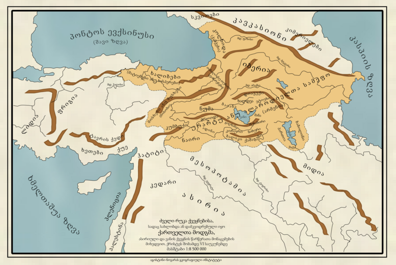
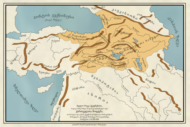
English: Map of the countries where Kartvelian peoples were settled or living untill the VI century BC. According to the data from Assyrian and Van Country scripts.
Scale 1:8 500 000 Credits: Geographic Institute Agustín Codazzi / Geographic Institute Of Novaraქართული: ძველი რუკა ქვეყნებისა, სადაც სახლობდა ან დამკვიდრებული იყო ქართველთა მოდგმა, ასირიული და ვანის ქვეყნის წარწერათა მონაცემების მიხედვით, ქრისტეს შობამდე VI საუკუნემდე
მასშტაბი 1:8 500 000 აგოსტინის გეოგრაფიული ინსტიტუტი, ნოვარა |
| Date | |
| Source | Travail personnel |
| Auteur | User:Ercwlff |
Conditions d’utilisation
Moi, en tant que détenteur des droits d’auteur sur cette œuvre, je la publie sous la licence suivante :
Ce fichier est sous la licence Creative Commons Attribution – Partage dans les Mêmes Conditions 4.0 International.
- Vous êtes libre :
- de partager – de copier, distribuer et transmettre cette œuvre
- d’adapter – de modifier cette œuvre
- Sous les conditions suivantes :
- paternité – Vous devez donner les informations appropriées concernant l'auteur, fournir un lien vers la licence et indiquer si des modifications ont été faites. Vous pouvez faire cela par tout moyen raisonnable, mais en aucune façon suggérant que l’auteur vous soutient ou approuve l’utilisation que vous en faites.
- partage à l’identique – Si vous modifiez, transformez, ou vous basez sur cette œuvre, vous devez distribuer votre contribution sous la même licence ou une licence compatible avec celle de l’original.
Historique du fichier
Cliquer sur une date et heure pour voir le fichier tel qu'il était à ce moment-là.
| Date et heure | Vignette | Dimensions | Utilisateur | Commentaire | |
|---|---|---|---|---|---|
| actuel | 19 décembre 2015 à 18:58 | | 2 000 × 1 338 (804 kio) | Ercwlff | User created page with UploadWizard |
Utilisation du fichier
La page suivante utilise ce fichier :
Usage global du fichier
Les autres wikis suivants utilisent ce fichier :
- Utilisation sur it.wikipedia.org
- Utilisation sur ka.wikipedia.org