
Fichier:Hokushin-ron-Map.svg

Taille de cet aperçu PNG pour ce fichier SVG : 800 × 512 pixels. Autres résolutions : 320 × 205 pixels | 640 × 409 pixels | 1 024 × 655 pixels | 1 280 × 819 pixels | 2 560 × 1 638 pixels | 1 038 × 664 pixels.
Fichier d’origine (Fichier SVG, nominalement de 1 038 × 664 pixels, taille : 649 kio)
Ce fichier et sa description proviennent de Wikimedia Commons.
| Description |
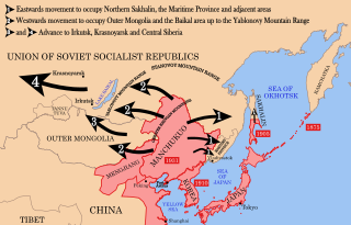
English: Strategic map of "Hoshukin-ron", the Japanese plans for a potential attack on the Soviet Union.
English: A map of the Imperial Powers of the Pacific, 1939-09-01. Dates shown indicate the approximate year that the various powers gain control of their possessions. Japanese control of territory in China was tenuous.
English: A Pacific-centered Mercator projection of the world with countries filled. Created in R using:
library(maps)
|
| Date | (UTC) |
| Source | |
| Auteur |
| Cette image a été retouchée, ce qui signifie qu'elle a été modifiée par ordinateur et est différente de l'image d'origine. Liste des modifications : Redrawn as vector image. L'image d'origine se trouve ici : Pacific Area - The Imperial Powers 1939 - Map.jpg:
|
Ce fichier est disponible selon les termes de la licence Creative Commons Attribution – Partage dans les Mêmes Conditions 3.0 (non transposée).
- Vous êtes libre :
- de partager – de copier, distribuer et transmettre cette œuvre
- d’adapter – de modifier cette œuvre
- Sous les conditions suivantes :
- paternité – Vous devez donner les informations appropriées concernant l'auteur, fournir un lien vers la licence et indiquer si des modifications ont été faites. Vous pouvez faire cela par tout moyen raisonnable, mais en aucune façon suggérant que l’auteur vous soutient ou approuve l’utilisation que vous en faites.
- partage à l’identique – Si vous modifiez, transformez, ou vous basez sur cette œuvre, vous devez distribuer votre contribution sous la même licence ou une licence compatible avec celle de l’original.
Journal des téléversements d’origine
This image is a derivative work of the following images:
- File:Hokushin-ron-Map.png licensed with Cc-by-sa-3.0, GFDL
- 2010-08-26T14:40:14Z Begoon 1013x615 (185183 Bytes) remove headline/tweak type
- 2010-01-13T18:41:06Z 36ophiuchi 1013x615 (248571 Bytes) Fixed some minor errors.
- 2010-01-11T23:12:35Z 36ophiuchi 1013x615 (246326 Bytes) {{Information |Description={{en|1=Strategic map of "Hoshukin-ron", the Japanese plans for a potential attack on the Soviet Union.}} |Source=*[[:File:Pacific_Area_-_The_Imperial_Powers_1939_-_Map.svg|]] |Date=2010-01-11 23:11
- File:Pacific_Area_-_The_Imperial_Powers_1939_-_Map.svg licensed with Cc-by-sa-3.0, GFDL
- 2010-08-27T15:13:24Z Splittist 1039x814 (4653684 Bytes) There's no need to create a new file. The map description shows that this map deviates from the one from which it originated: many borders were modified: e.x. East Timor, Mengjiang. It also welcomes changes based on better in
- 2010-08-27T10:11:31Z Kintetsubuffalo 1039x814 (4658296 Bytes) then you are welcome to create your own file, rather than editwarring
- 2010-08-27T06:54:08Z Splittist 1039x814 (4653684 Bytes) Well that map (not the govt, a military academy; and by no means are maps on the area consistent in borders) is wrong. Sheng Shicai, who pledged allegiance to China, controlled Xinjiang in 1939. Marking Xinjiang as separate i
- 2010-08-27T03:36:43Z Kintetsubuffalo 1039x814 (4658296 Bytes) the US government map this is based on shows it as separate
- 2010-08-27T01:26:43Z Splittist 1039x814 (4653684 Bytes) No reason for Xinjiang to have separate borders from China
- 2009-05-31T02:33:19Z Kmusser 1039x814 (4658296 Bytes) add macau, fix marianas, hainan spelling
- 2008-10-30T15:20:49Z Valentim 1039x814 (4703043 Bytes) Reverted to version as of 05:16, 22 September 2008. The international name is "Sea of Japan".
- 2008-09-24T07:42:22Z 쿠도군 1039x814 (4704268 Bytes) Reverted to version as of 07:53, 11 September 2008
- 2008-09-22T05:16:58Z Chris 73 1039x814 (4703043 Bytes) Reverted to version as of 02:54, 21 August 2008
- 2008-09-11T07:53:32Z 쿠도군 1039x814 (4704268 Bytes) new version.
- 2008-08-21T02:54:43Z Emok 1039x814 (4703043 Bytes) {{Information |Description= |Source= |Date= |Author= |Permission= |other_versions= }}
- 2008-08-21T02:44:29Z Emok 1039x814 (4702923 Bytes) {{Information |Description= |Source= |Date= |Author= |Permission= |other_versions= }}
- 2008-08-08T01:16:33Z Emok 1039x814 (4678233 Bytes) {{Information |Description= |Source= |Date= |Author= |Permission= |other_versions= }}
- 2008-08-08T00:07:48Z Emok 1039x814 (4669659 Bytes) {{Information |Description= |Source= |Date= |Author= |Permission= |other_versions= }}
- 2008-08-07T05:03:23Z Emok 1039x814 (4669195 Bytes) {{Information |Description= |Source= |Date= |Author= |Permission= |other_versions= }}
- 2008-08-07T04:28:58Z Emok 1039x814 (4623405 Bytes) {{Information |Description= |Source= |Date= |Author= |Permission= |other_versions= }}
- 2008-08-07T04:02:57Z Emok 1039x814 (4602891 Bytes) {{Information |Description= |Source= |Date= |Author= |Permission= |other_versions= }}
- 2008-08-07T03:24:03Z Emok 1039x814 (4669511 Bytes) {{Information |Description= |Source= |Date= |Author= |Permission= |other_versions= }}
- 2008-08-04T16:59:39Z Emok 1039x814 (6442489 Bytes) {{Information |Description= |Source= |Date= |Author= |Permission= |other_versions= }}
- 2008-08-04T05:38:24Z Emok 1039x814 (6427678 Bytes) {{Information |Description= |Source= |Date= |Author= |Permission= |other_versions= }} [[Category:Imperialism]] [[Category:Oceania]]
- 2008-08-04T05:26:00Z Emok 104x82 (4765313 Bytes) {{Information |Description={{en|1=A map of the Imperial Powers of the Pacific, 1939-09-01. }} |Source=*[[:Image:World2Hires_filled_mercator.svg|]] |Date=2008-08-04 05:22 (UTC) |Author=*derivative work: ~~~ *[[:Image:World2Hir
- File:World2Hires_filled_mercator.svg licensed with Cc-by-sa-3.0, GFDL
- 2008-08-03T06:38:19Z Emok 220x171 (12002488 Bytes) {{Information |Description= |Source= |Date= |Author= |Permission= |other_versions= }} [[Category:Blank SVG maps of the world]]
- 2008-08-03T06:00:29Z Emok 520x519 (3064180 Bytes) {{Information |Description={{en|1=A Pacific-centered Mercator projection of the world with countries filled.}} |Source=Own work by uploader |Author=[[User:Emok|Emok]] |Date=2008-08-01 |Permission= |other_versions= }} {{Image
- File:Pacific_Area_-_The_Imperial_Powers_1939_-_Map.jpg licensed with PD-USGov-Military-Army
Téléversé avec derivativeFX
Historique du fichier
Cliquer sur une date et heure pour voir le fichier tel qu'il était à ce moment-là.
| Date et heure | Vignette | Dimensions | Utilisateur | Commentaire | |
|---|---|---|---|---|---|
| actuel | 16 janvier 2012 à 05:37 | | 1 038 × 664 (649 kio) | Quigley | Xinjiang wasn't separate from China |
| 29 août 2010 à 07:40 |  | 1 038 × 664 (653 kio) | Begoon | emphasise relevant font weights | |
| 28 août 2010 à 12:04 |  | 1 038 × 664 (628 kio) | Begoon | you'd think a mountain range would be big enough not to miss - fixed font for last one... | |
| 28 août 2010 à 12:00 |  | 1 038 × 664 (626 kio) | Begoon | font weight for Mountain ranges/Pt Arthur | |
| 28 août 2010 à 11:43 |  | 1 038 × 664 (619 kio) | Begoon | {{Information |Description={{en|1=Strategic map of "Hoshukin-ron", the Japanese plans for a potential attack on the Soviet Union.}} {{en|1=A map of the Imperial Powers of the Pacific, 1939-09-01. Dates shown indicate the approximate year that the various |
Utilisation du fichier
La page suivante utilise ce fichier :
Usage global du fichier
Les autres wikis suivants utilisent ce fichier :
- Utilisation sur azb.wikipedia.org
- Utilisation sur az.wikipedia.org
- Utilisation sur bg.wikipedia.org
- Utilisation sur en.wikipedia.org
- Utilisation sur es.wikipedia.org
- Utilisation sur fa.wikipedia.org
- Utilisation sur he.wikipedia.org
- Utilisation sur id.wikipedia.org
- Utilisation sur it.wikipedia.org
- Utilisation sur ja.wikipedia.org
- Utilisation sur ko.wikipedia.org
- Utilisation sur mn.wikipedia.org
- Utilisation sur ms.wikipedia.org
- Utilisation sur no.wikipedia.org
- Utilisation sur pt.wikipedia.org
- Utilisation sur ru.wikipedia.org
- Utilisation sur uk.wikipedia.org
- Utilisation sur www.wikidata.org
- Utilisation sur zh.wikipedia.org