
Fichier:High Street, Bramley opposite the Library - geograph.org.uk - 527410.jpg
Pas de plus haute résolution disponible.
High_Street,_Bramley_opposite_the_Library_-_geograph.org.uk_-_527410.jpg (640 × 519 pixels, taille du fichier : 127 kio, type MIME : image/jpeg)
Ce fichier et sa description proviennent de Wikimedia Commons.
Description
| Description |
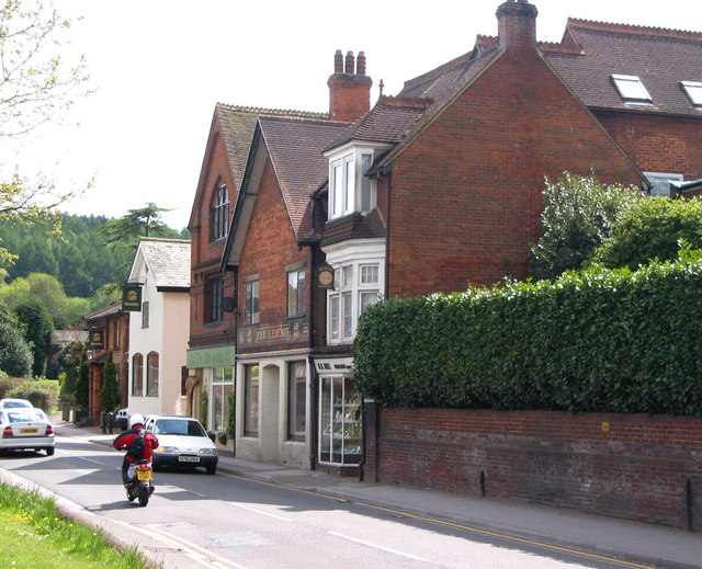
English: High Street, Bramley opposite the Library The tall Victorian building is the site of the Bramley Brewery, owned by the Smith family. Beer was brewed on this site from 1865 by William Smith. In 1901 his son Morton Smith was listed on the census as brewer and jeweller. In 1904 it was bought by Brufords of Cranleigh and in 1917 it was taken over by Cobham United Breweries.
Further down, still visible in the photo, was the Foundry also owned by the Smith family. Charles Smith, William's father bought the foundry in 1847. |
| Date | |
| Source | From geograph.org.uk |
| Auteur | Clare |
| Attribution (imposé par la licence) | Clare / High Street, Bramley opposite the Library / |
| Lieu de la prise de vue | | Voir cet endroit et d’autres images sur : OpenStreetMap |
|---|
_heading:180.00&language=fr)
| Position de l'objet | | Voir cet endroit et d’autres images sur : OpenStreetMap |
|---|
_heading:180.00&language=fr)
Conditions d’utilisation

|
Cette image provient de la collection du projet Geograph British Isles. Pour obtenir les coordonnées du photographe, veuillez consulter cette page de description de l'image sur le site du projet. Les droits d'auteurs sur cette image sont détenus par Clare ; l'image est placée sous une licence Creative Commons avec mention de paternité et partage à l'identique (CC-By-SA) en version 2.0.
|
Ce fichier est disponible selon les termes de la licence Creative Commons Attribution – Partage dans les Mêmes Conditions 2.0 Générique
Attribution: Clare
- Vous êtes libre :
- de partager – de copier, distribuer et transmettre cette œuvre
- d’adapter – de modifier cette œuvre
- Sous les conditions suivantes :
- paternité – Vous devez donner les informations appropriées concernant l'auteur, fournir un lien vers la licence et indiquer si des modifications ont été faites. Vous pouvez faire cela par tout moyen raisonnable, mais en aucune façon suggérant que l’auteur vous soutient ou approuve l’utilisation que vous en faites.
- partage à l’identique – Si vous modifiez, transformez, ou vous basez sur cette œuvre, vous devez distribuer votre contribution sous la même licence ou une licence compatible avec celle de l’original.
Historique du fichier
Cliquer sur une date et heure pour voir le fichier tel qu'il était à ce moment-là.
| Date et heure | Vignette | Dimensions | Utilisateur | Commentaire | |
|---|---|---|---|---|---|
| actuel | 5 février 2011 à 18:28 | | 640 × 519 (127 kio) | GeographBot | == {{int:filedesc}} == {{Information |description={{en|1=High Street, Bramley opposite the Library The tall Victorian building is the site of the Bramley Brewery, owned by the Smith family. Beer was brewed on this site from 1865 by William Smith. In 1901 |
Utilisation du fichier
La page suivante utilise ce fichier :
Usage global du fichier
Les autres wikis suivants utilisent ce fichier :
- Utilisation sur azb.wikipedia.org
- Utilisation sur ceb.wikipedia.org
- Utilisation sur cy.wikipedia.org
- Utilisation sur en.wikipedia.org
- Utilisation sur es.wikipedia.org
- Utilisation sur fa.wikipedia.org
- Utilisation sur id.wikipedia.org
- Utilisation sur lld.wikipedia.org
- Utilisation sur no.wikipedia.org
- Utilisation sur pl.wikipedia.org
- Utilisation sur www.wikidata.org
- Utilisation sur zh-min-nan.wikipedia.org