
Fichier:Goethals Map of the Gatun Dam.jpg

Fichier d’origine (1 045 × 762 pixels, taille du fichier : 128 kio, type MIME : image/jpeg)
Ce fichier et sa description proviennent de Wikimedia Commons.
Description
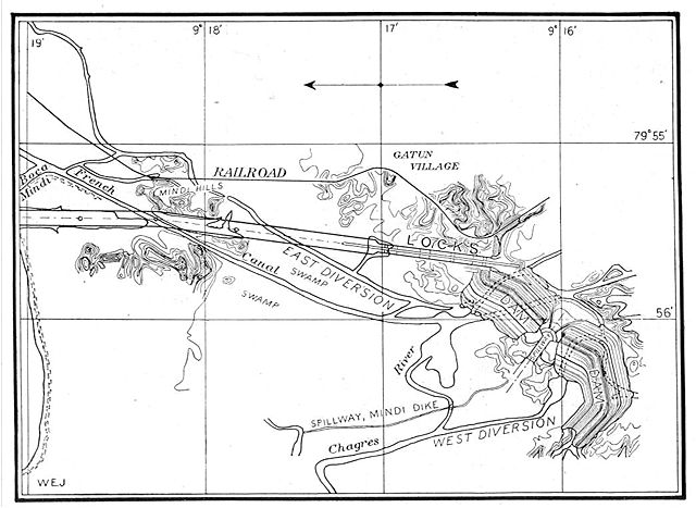
This map from the construction of the Panama Canal illustrates the north end of the canal, showing the area around the Gatun locks and Gatun Dam. The proposed lock and dam structures are shown superposed over the waterways existing at the end of the French attempt to build a sea-level canal there. North is to the left.
From An address to the National Geographic Society by George Washington Goethals, February 10, 1911.
Conditions d’utilisation
Ce document est dans le domaine public aux États-Unis. Ceci s'applique aux travaux des États-Unis où le copyright a expiré, souvent parce que sa première publication s'est produite avant le 1er janvier 1929. Voir cette page pour davantage d'explication.
|
 | |
 |
Cette image peut ne pas être dans le domaine public en dehors des États-Unis (ceci s'applique particulièrement au Canada, en Chine (pas Hong Kong, Macao, ni Taïwan), en Allemagne ou en Suisse). Le créateur et l'année de la publication sont l'information essentielle et doivent être fournis.
|
Historique du fichier
Cliquer sur une date et heure pour voir le fichier tel qu'il était à ce moment-là.
| Date et heure | Vignette | Dimensions | Utilisateur | Commentaire | |
|---|---|---|---|---|---|
| actuel | 29 octobre 2005 à 19:42 | | 1 045 × 762 (128 kio) | Johantheghost | This map from the construction of the Panama Canal illustrates the north end of the canal, showing the area around the Gatun locks and Gatun Dam. The proposed lock and dam structures are shown superposed |
Utilisation du fichier
La page suivante utilise ce fichier :
Usage global du fichier
Les autres wikis suivants utilisent ce fichier :
- Utilisation sur ca.wikipedia.org
- Utilisation sur cs.wikipedia.org
- Utilisation sur de.wikipedia.org
- Utilisation sur en.wikipedia.org
- Utilisation sur es.wikipedia.org