
Fichier:EU OCT and OMR map en.png
Taille de cet aperçu : 800 × 492 pixels. Autres résolutions : 320 × 197 pixels | 640 × 394 pixels | 1 024 × 630 pixels | 1 280 × 788 pixels | 2 206 × 1 358 pixels.
Fichier d’origine (2 206 × 1 358 pixels, taille du fichier : 1 003 kio, type MIME : image/png)
Ce fichier et sa description proviennent de Wikimedia Commons.

|
Une version vectorielle de cette image existe, dans le format « SVG ». Si elle n’est pas inférieure, elle devrait être utilisée à la place de la présente version pour des affichages en plus grandes dimensions ou nécessitant une meilleure résolution.
File:EU OCT and OMR map en.png → File:Special member state territories and the European Union.svg
Pour plus d’informations sur les images vectorielles, consultez la page de transition de Commons vers le format SVG. Voir aussi les informations à propos de la manière dont le logiciel MediaWiki gère les images au format SVG. |
 |
Description
| Description |
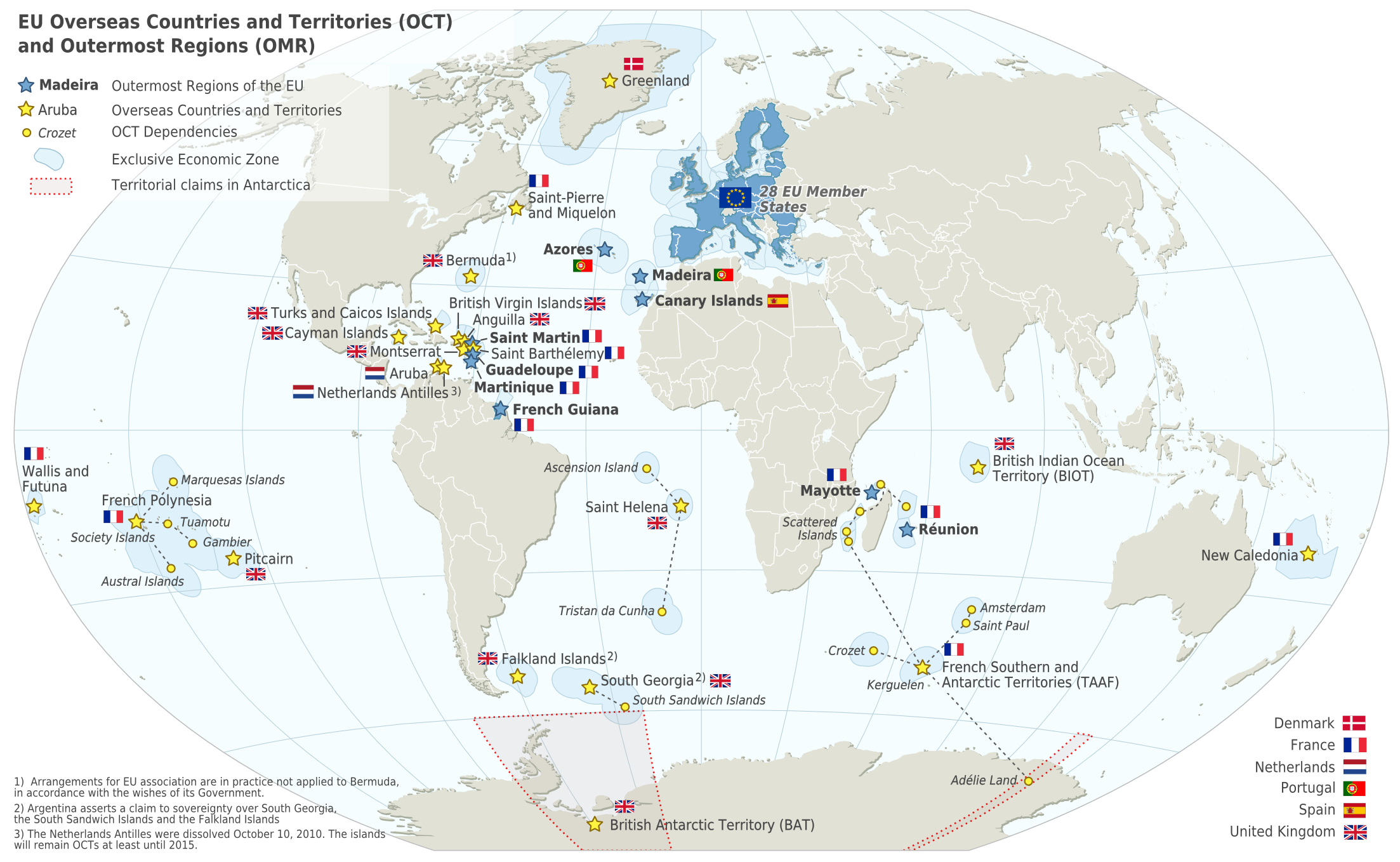
Deutsch: Karte der EU – Überseeische Länder und Hoheitsgebiete (OCT) und die Gebiete in äußerster Randlage (OMR). Diese Karte zeigt den räumlichen Geltungsbereich der Verträge der EU gemäß Artikel 52 des Vertrags über die Europäische Union und Artikel 355 des Vertrags über die Arbeitsweise der Europäischen Union.
Français : Carte de l’Union Européenne, en particulier les Pays et territoires d’outre-mer et les Régions ultrapériphériques. Cette carte montre la portée d’action territoriale des Traités de l’UE comme spécifié par l’Article 52 du Traité sur l’Union Européenne et l’Article 355 du Traité sur le Fonctionnement de l’Union Européenne.
English: Map of the EU – Overseas Countries and Territories (OCT) and Outermost Regions (OMR). This map shows the territorial scope of the Treaties of the EU as specified by Article 52 of the Treaty on European Union and Article 355 of the Treaty on the Functioning of the European Union. |
| Date | |
| Source | Natural Earth 1:50m (http://www.naturalearthdata.com) |
| Auteur | Alexrk2 |
| Autres versions |
|
![[ar] Arabic version \ النسخة العربية](http://commons.wikimedia.org/wiki/File:Map-Europe-Outermost-regions-ar.PNG)
![[de] German version / deutsche Version](http://commons.wikimedia.org/wiki/File:Map-Europe-Outermost-regions-de.png)
![[fr] French version / version français](http://commons.wikimedia.org/wiki/File:Map-Europe-Outermost-regions-fr.png)


|
Cette carte a été créée ou améliorée dans le Kartenwerkstatt (Atelier cartographique allemand). Vous pouvez également y proposer des cartes à améliorer.
|
Cette image matricielle PNG a été créée avec Inkscape .
Conditions d’utilisation
Moi, en tant que détenteur des droits d’auteur sur cette œuvre, je la publie sous la licence suivante :
Ce fichier est disponible selon les termes de la licence Creative Commons Attribution – Partage dans les Mêmes Conditions 3.0 (non transposée).
- Vous êtes libre :
- de partager – de copier, distribuer et transmettre cette œuvre
- d’adapter – de modifier cette œuvre
- Sous les conditions suivantes :
- paternité – Vous devez donner les informations appropriées concernant l'auteur, fournir un lien vers la licence et indiquer si des modifications ont été faites. Vous pouvez faire cela par tout moyen raisonnable, mais en aucune façon suggérant que l’auteur vous soutient ou approuve l’utilisation que vous en faites.
- partage à l’identique – Si vous modifiez, transformez, ou vous basez sur cette œuvre, vous devez distribuer votre contribution sous la même licence ou une licence compatible avec celle de l’original.
Historique du fichier
Cliquer sur une date et heure pour voir le fichier tel qu'il était à ce moment-là.
| Date et heure | Vignette | Dimensions | Utilisateur | Commentaire | |
|---|---|---|---|---|---|
| actuel | 18 février 2024 à 08:14 | | 2 206 × 1 358 (1 003 kio) | Sqrt of 2 | Reverted to version as of 18:05, 12 June 2023 (UTC) |
| 15 janvier 2024 à 18:08 |  | 2 206 × 1 358 (954 kio) | Multituberculata | Reverted to version as of 08:53, 31 May 2023 (UTC) | |
| 12 juin 2023 à 20:05 |  | 2 206 × 1 358 (1 003 kio) | DecafPotato | Reverted to version as of 14:48, 27 February 2019 (UTC) – The image includes UK territories, and was made prior to Brexit; please keep the UK in the map as part of the European Union for this reason | |
| 31 mai 2023 à 10:53 |  | 2 206 × 1 358 (954 kio) | Iktsokh | Note | |
| 21 mai 2023 à 22:01 |  | 2 206 × 1 358 (951 kio) | Iktsokh | Correction | |
| 18 mai 2023 à 11:56 |  | 2 206 × 1 358 (950 kio) | Iktsokh | Updated | |
| 27 février 2019 à 16:48 |  | 2 206 × 1 358 (1 003 kio) | Radom1967 | Reverted to version as of 17:02, 22 March 2018 (UTC). No need | |
| 25 février 2019 à 14:13 |  | 2 206 × 1 358 (999 kio) | Odemirense | Countries with overseas regions in dark blue | |
| 22 mars 2018 à 19:02 |  | 2 206 × 1 358 (1 003 kio) | Maphobbyist | South Sudan border | |
| 1 janvier 2014 à 20:24 |  | 2 206 × 1 358 (1 Mio) | Alexrk2 | From 1 January 2014, the status of Mayotte will be that of an outermost region (COUNCIL DIRECTIVE 2013/61/EU of 17 December 2013) |
Utilisation du fichier
Aucune page n’utilise ce fichier.
Usage global du fichier
Les autres wikis suivants utilisent ce fichier :
- Utilisation sur an.wikipedia.org
- Utilisation sur ar.wikipedia.org
- Utilisation sur ast.wikipedia.org
- Utilisation sur azb.wikipedia.org
- Utilisation sur bn.wikipedia.org
- Utilisation sur ca.wikipedia.org
- Utilisation sur cs.wikipedia.org
- Utilisation sur en.wikipedia.org
- Aruba
- Canary Islands
- Greenland
- Guadeloupe
- Martinique
- Mayotte
- Madeira
- Netherlands Antilles
- Réunion
- Overseas departments and regions of France
- Decolonisation of Africa
- History of colonialism
- Sint Maarten
- French Guiana
- User:Kazkaskazkasako/Books/All
- Caribbean Netherlands
- User:Tom29739/The EU
- User:Abyssal/bla
- List of colonies
- User:Falcaorib/World Alliances
- Utilisation sur en.wikiquote.org
- Utilisation sur en.wikivoyage.org
- Utilisation sur es.wikipedia.org
- Utilisation sur fa.wikipedia.org
- Utilisation sur fi.wikipedia.org
- Utilisation sur gl.wikipedia.org
- Utilisation sur id.wikipedia.org
- Utilisation sur ilo.wikipedia.org
- Utilisation sur it.wikipedia.org
- Utilisation sur ka.wikipedia.org
- Utilisation sur mk.wikipedia.org
- Utilisation sur nds-nl.wikipedia.org
Voir davantage sur l’utilisation globale de ce fichier.