
Fichier:1st-SOUSE-sensors.png
Pas de plus haute résolution disponible.
1st-SOUSE-sensors.png (300 × 280 pixels, taille du fichier : 155 kio, type MIME : image/png)
Ce fichier et sa description proviennent de Wikimedia Commons.
Description
| Description |
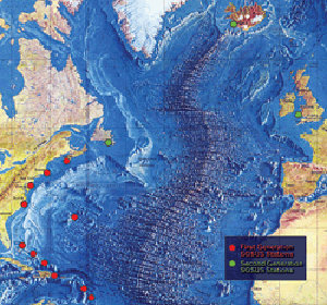
English: The first SOSUS stations – NAVFACs – were sited from Barbados to Nova Scotia on a huge semi-circle that opened onto the deepwater abyss west of the Mid-Atlantic Ridge. Later, additional Atlantic-area stations were established at Argentia, Newfoundland, Keflavik, Iceland, and Brawdy, Wales.
Polski: Pierwsze stacje Sound Surveillance System - NAVFAC rozmieszczone pomiędzy barbados i Nową Szkocją w wielkim półkolu wzdłuz wschodniego wybrzeża USA. Dodatkowe stacje rozmieszczone były miedzy Nową Fundlandią, Islandią i Walią |
| Source | http://www.navy.mil/navydata/cno/n87/usw/issue_25/sosus.htm (archived source) |
| Auteur | Edward C. Whitman/US Navy |
Conditions d’utilisation
Cette image est l'œuvre d'un marin ou d'un employé de l'U.S. Navy, créée dans l'exercice de ses fonctions. En tant qu'œuvre du gouvernement fédéral des États-Unis, cette image est dans le domaine public.
|
 | |
| Ce fichier a été identifié comme étant exempt de restrictions connues liées au droit d’auteur, y compris tous les droits connexes et voisins. | ||
Historique du fichier
Cliquer sur une date et heure pour voir le fichier tel qu'il était à ce moment-là.
| Date et heure | Vignette | Dimensions | Utilisateur | Commentaire | |
|---|---|---|---|---|---|
| actuel | 5 août 2008 à 02:51 | | 300 × 280 (155 kio) | Matrek | {{Information |Description={{en|1=The first SOSUS stations – NAVFACs – were sited from Barbados to Nova Scotia on a huge semi-circle that opened onto the deepwater abyss west of the Mid-Atlantic Ridge. Later, additional Atlantic-area stations were est |
Utilisation du fichier
La page suivante utilise ce fichier :
Usage global du fichier
Les autres wikis suivants utilisent ce fichier :
- Utilisation sur en.wikipedia.org
- Utilisation sur es.wikipedia.org
- Utilisation sur et.wikipedia.org
- Utilisation sur id.wikipedia.org
- Utilisation sur it.wikipedia.org
- Utilisation sur ko.wikipedia.org
- Utilisation sur pl.wikipedia.org
- Utilisation sur sv.wikipedia.org
- Utilisation sur vi.wikipedia.org
- Utilisation sur zh.wikipedia.org