
Fichier:1855 U.S. Coast Survey Chart or Map of the Savanna River, Georgia - Geographicus - SavannahRiver-uscs-1855.jpg

Fichier d’origine (6 000 × 3 545 pixels, taille du fichier : 3,35 Mio, type MIME : image/jpeg)
Ce fichier et sa description proviennent de Wikimedia Commons.
| (E No. 6) Preliminary Chart of Savannah River Georgia. | ||||||
|---|---|---|---|---|---|---|
| Artiste | ||||||
| Titre |
(E No. 6) Preliminary Chart of Savannah River Georgia. |
|||||
| Description |
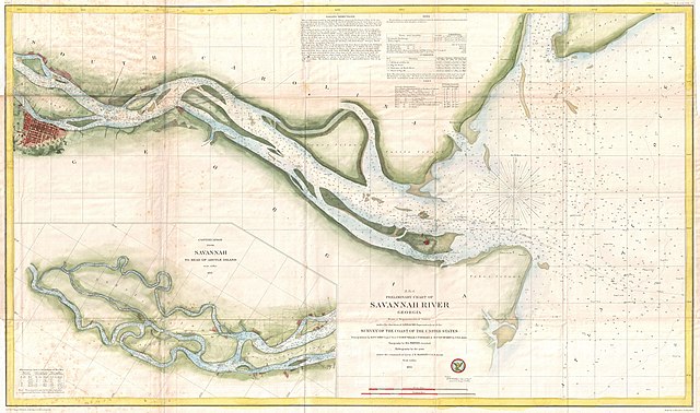
English: This is a very attractive example of the 1855 U.S. Coast Survey nautical chart or map of the Savannah River, Georgia. Centered on Jones Island, this map extends from the river’s mouth at Tybee and Turtle Islands inland as far as the city of Savannah, which is itself drawn in considerable detail. This chart notes Fort Pulaski at the mouth of the river as well as the Fort Jackson and the Union Causeway. The city of Savannah itself is beautifully rendered with its hallmark grid structure and even important buildings and parks clearly in evidence. The lower left quadrant features an inset that continues the map from Savannah westward to Argyle Island. The triangulation for this map was completed by E.O. Cord, C. O. Boutelle, C. P. Bolles and D. T. Van Buren. The topography is the work of H. I. Whiting. The Hydrography was accomplished by a party under the command of J. N. Maffitt. The entire chart was produced under the supervision of A. D. Bache, of the most prolific and influential Superintendents of the U.S. Coast Survey. |
|||||
| Date | 1855 (dated) | |||||
| Dimensions | hauteur : 20 pouces (50,8 cm) ; largeur : 33 pouces (83,8 cm) | |||||
| Numéro d’inventaire |
liens Geographicus : SavannahRiver-uscs-1855 |
|||||
| Source / photographe |
Report of the Superintendant of the United States Coast Survey, (Washington) 1855.
|
|||||
| Autorisation (Réutilisation de ce fichier) |
|
|||||
| Position de l'objet | | Voir cet endroit et d’autres images sur : OpenStreetMap |
|---|
| Annotations | Cette image est annotée : Voir les annotations sur Wikimedia Commons |
Historique du fichier
Cliquer sur une date et heure pour voir le fichier tel qu'il était à ce moment-là.
| Date et heure | Vignette | Dimensions | Utilisateur | Commentaire | |
|---|---|---|---|---|---|
| actuel | 25 mars 2011 à 07:26 | | 6 000 × 3 545 (3,35 Mio) | BotMultichillT | {{subst:User:Multichill/Geographicus |link=http://www.geographicus.com/P/AntiqueMap/SavannahRiver-uscs-1855 |product_name=1855 U.S. Coast Survey Chart or Map of the Savanna River, Georgia |map_title=(E No. 6) Preliminary Chart of Savannah River Georgia. | |
Utilisation du fichier
La page suivante utilise ce fichier :
Usage global du fichier
Les autres wikis suivants utilisent ce fichier :
- Utilisation sur en.wikipedia.org
- Utilisation sur ja.wikipedia.org