
Fichier:1814 Thomson Map of the Atlantic Ocean - Geographicus - Atlantic-t-1814.jpg
Taille de cet aperçu : 751 × 599 pixels. Autres résolutions : 301 × 240 pixels | 602 × 480 pixels | 963 × 768 pixels | 1 280 × 1 021 pixels | 2 560 × 2 043 pixels | 5 000 × 3 990 pixels.
Fichier d’origine (5 000 × 3 990 pixels, taille du fichier : 2,94 Mio, type MIME : image/jpeg)
Ce fichier et sa description proviennent de Wikimedia Commons.
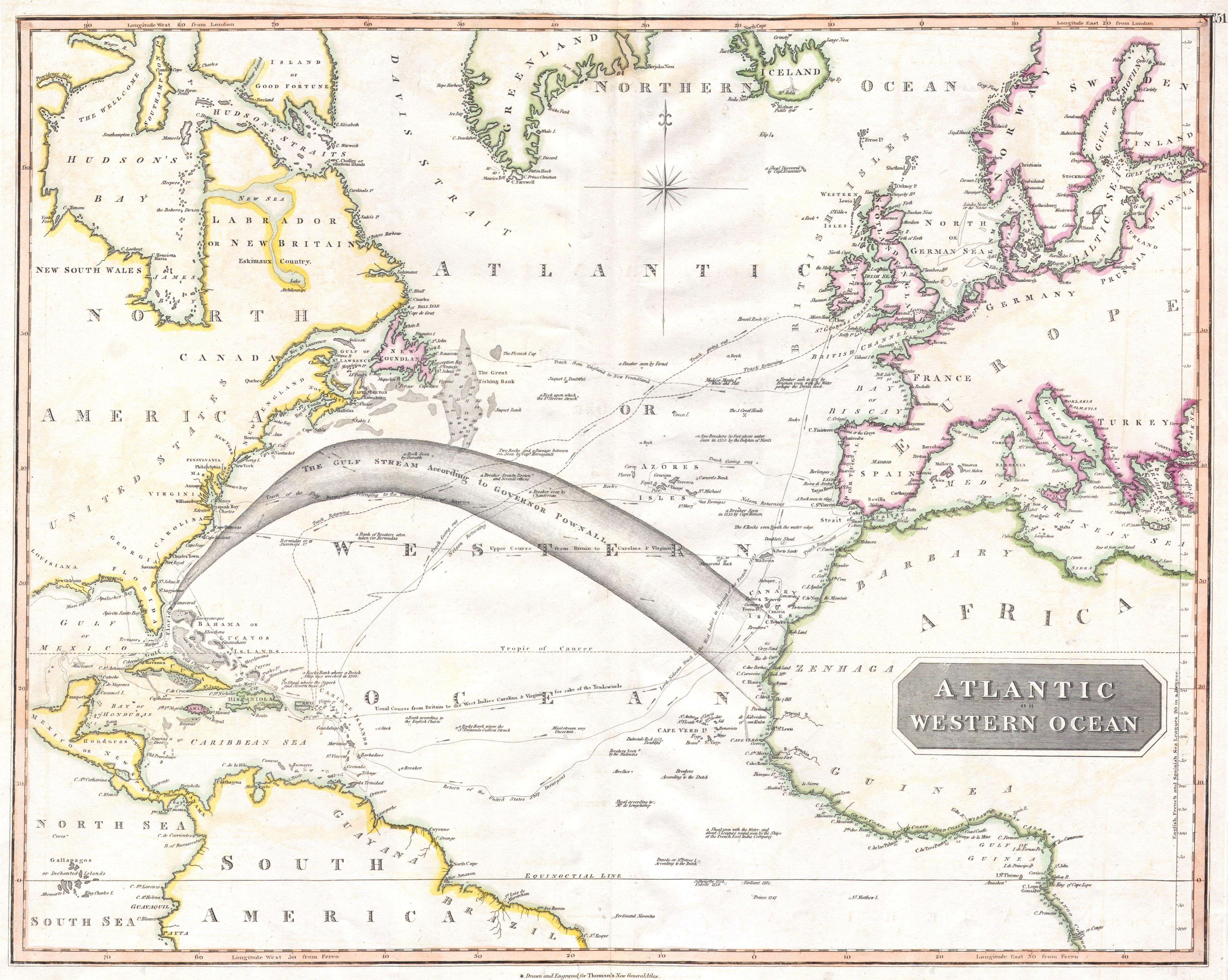
| John Thomson : Atlantic or Western Ocean.
( |
||||||||||||||
|---|---|---|---|---|---|---|---|---|---|---|---|---|---|---|
| Artiste |
|
|||||||||||||
| Titre |
Atlantic or Western Ocean. |
|||||||||||||
| Description |
English: This fascinating hand colored 1814 map by Edinburgh cartographer John Thomson depicts the northern part of the Atlantic Ocean. Extends as for north as Iceland and as far south as Brazil and the Congo. Made during the Napoleonic wars, this stunning map includes references to important battles and nautical routes of the period, including the route taken by Lord Nelson in pursuit of the French in 1805. Also includes path of the Insurgent, which disappeared in the West Indies after being harassed by the French navy, eventually giving rise to the Bermuda Triangle legend. Features a host of nautical notations on the Gulf Stream current, breakers, banks, trade winds and even a supposed “Maalstroom very Uncertain (West of the Cape Verde Islands).” Inland detail is minimal though important port cities and regions are noted. |
|||||||||||||
| Date | 1814 | |||||||||||||
| Dimensions | hauteur : 20 pouces (50,8 cm) ; largeur : 25 pouces (63,5 cm) | |||||||||||||
| Numéro d’inventaire |
liens Geographicus : Atlantic-t-1814 |
|||||||||||||
| Source / photographe |
|
|||||||||||||
| Autorisation (Réutilisation de ce fichier) |
|
|||||||||||||
Historique du fichier
Cliquer sur une date et heure pour voir le fichier tel qu'il était à ce moment-là.
| Date et heure | Vignette | Dimensions | Utilisateur | Commentaire | |
|---|---|---|---|---|---|
| actuel | 24 mars 2011 à 16:40 | | 5 000 × 3 990 (2,94 Mio) | BotMultichillT | {{subst:User:Multichill/Geographicus |link=http://www.geographicus.com/P/AntiqueMap/Atlantic-t-1814 |product_name=1814 Thomson Map of the Atlantic Ocean |map_title=Atlantic or Western Ocean. |description=This fascinating hand colored 1814 map by Edinbur |
Utilisation du fichier
Les 2 pages suivantes utilisent ce fichier :
Usage global du fichier
Les autres wikis suivants utilisent ce fichier :
- Utilisation sur en.wikipedia.org
- Utilisation sur es.wikipedia.org
- Utilisation sur it.wikipedia.org