
Fichier:The Florida straits, the L-shaped channel between southeastern Florida and the Bahamas, and the Florida Keys and Cuba.gif

Taille de cet aperçu : 650 × 600 pixels. Autres résolutions : 260 × 240 pixels | 520 × 480 pixels | 832 × 768 pixels | 1 109 × 1 024 pixels | 1 300 × 1 200 pixels.
Fichier d’origine (1 300 × 1 200 pixels, taille du fichier : 618 kio, type MIME : image/gif)
Ce fichier et sa description proviennent de Wikimedia Commons.
Description
| Description |
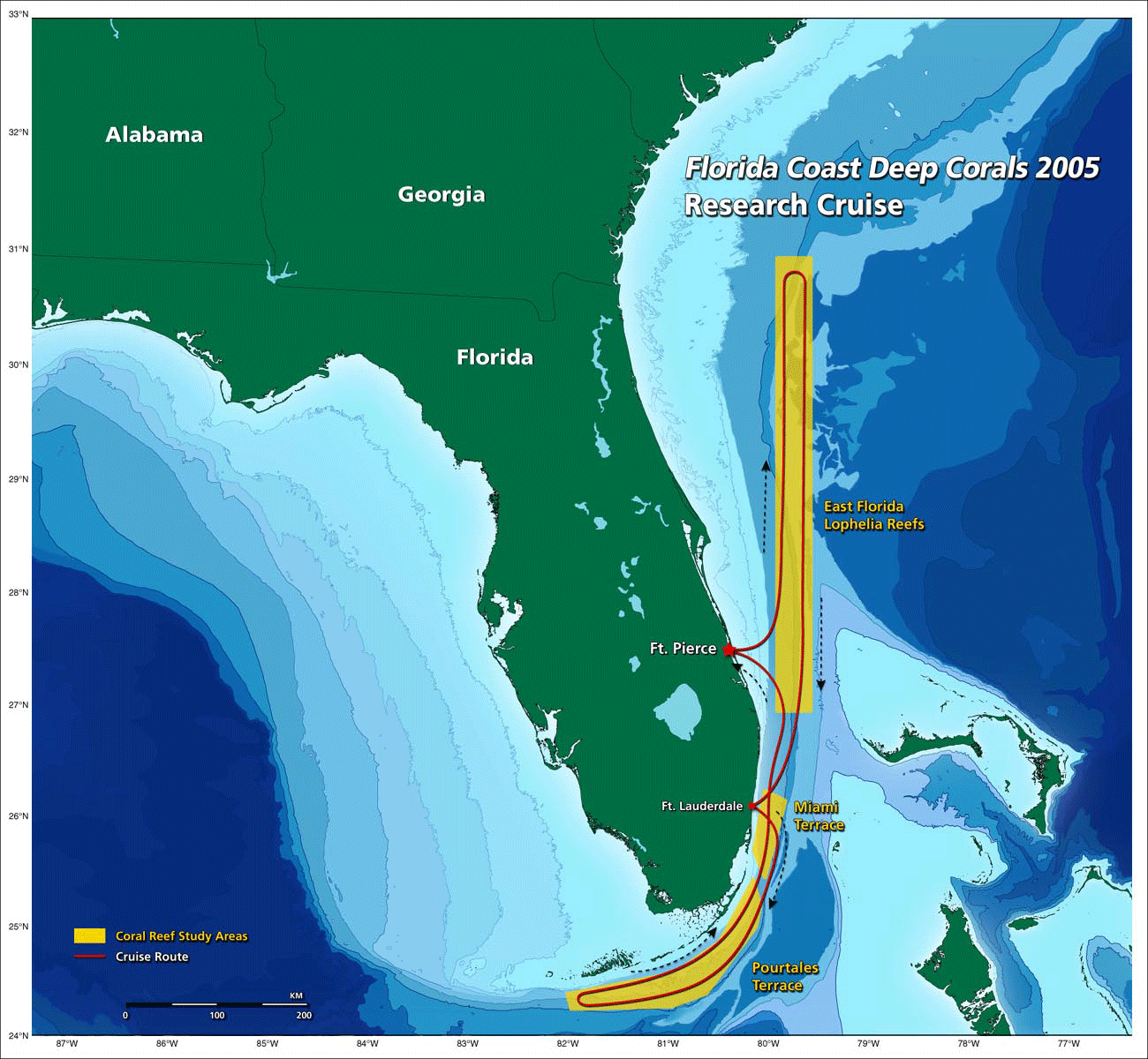
English: the Florida straits, the L-shaped channel between southeastern Florida and the Bahamas, and the Florida Keys and Cuba.[1] |
| Date | 20:22, 30 October 2009 (UTC) |
| Source | http://oceanexplorer.noaa.gov/explorations/05deepcorals/background/mission_plan/media/map_600.gif |
| Auteur | Image courtesy of NOAA OE. |
| Autorisation (Réutilisation de ce fichier) |
U.S. Government work |
Conditions d’utilisation
Cette image est dans le domaine public car son contenu provient de la
National Oceanic and Atmospheric Administration , réalisé par un employé dans le cadre de ses activités professionnelles.
|
Historique du fichier
Cliquer sur une date et heure pour voir le fichier tel qu'il était à ce moment-là.
| Date et heure | Vignette | Dimensions | Utilisateur | Commentaire | |
|---|---|---|---|---|---|
| actuel | 30 octobre 2009 à 22:22 | | 1 300 × 1 200 (618 kio) | Mattisse | {{Information |Description = the Florida straits, the L-shaped channel between southeastern Florida and the Bahamas, and the Florida Keys and Cuba.[http://oceanexplorer.noaa.gov/explorations/05deepcorals/background/mission_plan/media/map_600.html] |S |
Utilisation du fichier
La page suivante utilise ce fichier :
Usage global du fichier
Les autres wikis suivants utilisent ce fichier :
- Utilisation sur arz.wikipedia.org
- Utilisation sur ca.wikipedia.org
- Utilisation sur en.wikipedia.org