
Fichier:Operation Tractable.png
Taille de cet aperçu : 491 × 600 pixels. Autres résolutions : 196 × 240 pixels | 550 × 672 pixels.
Fichier d’origine (550 × 672 pixels, taille du fichier : 136 kio, type MIME : image/png)
Ce fichier et sa description proviennent de Wikimedia Commons.

|
Une version vectorielle de cette image existe, dans le format « SVG ». Si elle n’est pas inférieure, elle devrait être utilisée à la place de la présente version pour des affichages en plus grandes dimensions ou nécessitant une meilleure résolution.
File:Operation Tractable.png → File:Operation Tractable.svg
Pour plus d’informations sur les images vectorielles, consultez la page de transition de Commons vers le format SVG. Voir aussi les informations à propos de la manière dont le logiciel MediaWiki gère les images au format SVG. |
 |
Description
| Description |
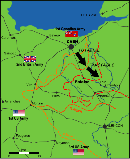
English: Map of Allied and German positions around Falaise, Normandy from 8-17 August 1944, illustrating the Canadian offensives of Operation Totalize and Operation Tractable. |
| Date | |
| Source | Travail personnel |
| Auteur | EyeSerene |
New version uploaded to correct mistake in original, 10 October 2008.
Conditions d’utilisation
| Moi, propriétaire des droits d’auteur sur cette œuvre, la place dans le domaine public. Ceci s'applique dans le monde entier. Dans certains pays, ceci peut ne pas être possible ; dans ce cas : J’accorde à toute personne le droit d’utiliser cette œuvre dans n’importe quel but, sans aucune condition, sauf celles requises par la loi. |
Historique du fichier
Cliquer sur une date et heure pour voir le fichier tel qu'il était à ce moment-là.
| Date et heure | Vignette | Dimensions | Utilisateur | Commentaire | |
|---|---|---|---|---|---|
| actuel | 20 avril 2012 à 02:46 | | 550 × 672 (136 kio) | Kbh3rd | Added map scale bar |
| 17 janvier 2010 à 19:58 |  | 550 × 672 (105 kio) | Mahahahaneapneap | Compressed | |
| 27 avril 2009 à 12:12 |  | 550 × 672 (135 kio) | EyeSerene | Replace Maple Leaf flag with Red Ensign | |
| 10 octobre 2008 à 18:59 |  | 550 × 672 (149 kio) | EyeSerene | {{Information |Description= |Source= |Date= |Author= |Permission= |other_versions= }} | |
| 3 octobre 2008 à 21:17 |  | 550 × 672 (149 kio) | EyeSerene | {{Information |Description={{en|1=Map of Allied and German positions around Falaise, Normandy from 8-17 August 1944, illustrating the Canadian offensives of Operation Totalize and Operation Tractable.}} |Source=Own work by uploader |Author=[[User:EyeSeren |
Utilisation du fichier
La page suivante utilise ce fichier :
Usage global du fichier
Les autres wikis suivants utilisent ce fichier :
- Utilisation sur da.wikipedia.org
- Utilisation sur en.wikipedia.org
- Utilisation sur ru.wikipedia.org
- Utilisation sur zh.wikipedia.org