
Fichier:Ohridski-Map.PNG

Taille de cet aperçu : 475 × 600 pixels. Autres résolutions : 190 × 240 pixels | 380 × 480 pixels | 608 × 768 pixels | 811 × 1 024 pixels | 1 622 × 2 048 pixels | 2 849 × 3 598 pixels.
Fichier d’origine (2 849 × 3 598 pixels, taille du fichier : 29,38 Mio, type MIME : image/png)
Ce fichier et sa description proviennent de Wikimedia Commons.
Description
| Description |
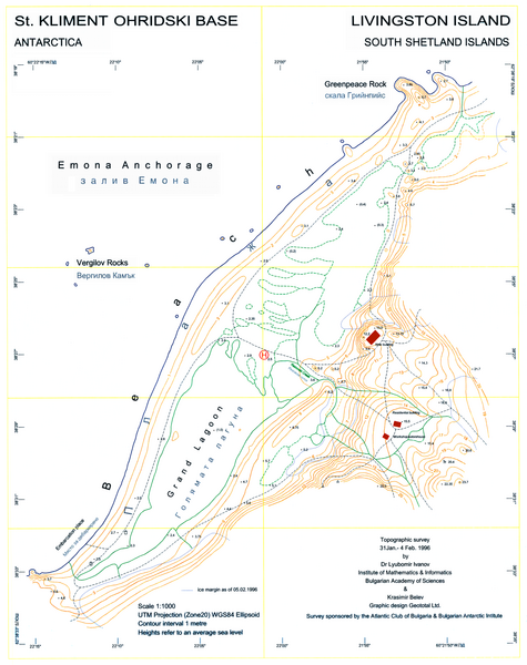
English: L.L. Ivanov, St. Kliment Ohridski Base, Livingston Island, 1:1 000 scale topographic map, Commissioned by the Antarctic Place-names Commission of Bulgaria, sponsored by the Atlantic Club of Bulgaria and the Bulgarian Antarctic Institute, Sofia, 1996. The first Bulgarian Antarctic topographic map.
Note: 'New building' actually refers to the foundations of the new main building of the Bulgarian Base as of 1996; the building itself was completed in 1998. |
| Date | |
| Source | Travail personnel |
| Auteur | User:Apcbg |
| Autres versions | File:Ohridski-Map.jpg |
| Lieu de la prise de vue | | Voir cet endroit et d’autres images sur : OpenStreetMap |
|---|
Conditions d’utilisation
Moi, en tant que détenteur des droits d’auteur sur cette œuvre, je la publie sous la licence suivante :
Ce fichier est sous la licence Creative Commons Attribution – Partage dans les Mêmes Conditions 4.0 International.
- Vous êtes libre :
- de partager – de copier, distribuer et transmettre cette œuvre
- d’adapter – de modifier cette œuvre
- Sous les conditions suivantes :
- paternité – Vous devez donner les informations appropriées concernant l'auteur, fournir un lien vers la licence et indiquer si des modifications ont été faites. Vous pouvez faire cela par tout moyen raisonnable, mais en aucune façon suggérant que l’auteur vous soutient ou approuve l’utilisation que vous en faites.
- partage à l’identique – Si vous modifiez, transformez, ou vous basez sur cette œuvre, vous devez distribuer votre contribution sous la même licence ou une licence compatible avec celle de l’original.
Historique du fichier
Cliquer sur une date et heure pour voir le fichier tel qu'il était à ce moment-là.
| Date et heure | Vignette | Dimensions | Utilisateur | Commentaire | |
|---|---|---|---|---|---|
| actuel | 27 juillet 2010 à 10:25 | | 2 849 × 3 598 (29,38 Mio) | Apcbg | Decreased size to less than 12.5 million pixels. |
| 27 juillet 2010 à 10:14 |  | 3 561 × 4 497 (3,52 Mio) | Apcbg | A redrawn version of the map. | |
| 23 mai 2009 à 10:58 |  | 2 762 × 3 317 (1,26 Mio) | Apcbg | {{Information |Description={{en|1=L.L. Ivanov, St. Kliment Ohridski Base, Livingston Island, 1:1 000 scale topographic map, Commissioned by the Antarctic Place-names Commission of Bulgaria, sponsored by the Atlantic Club of Bulgaria and the Bulgarian Anta |
Utilisation du fichier
La page suivante utilise ce fichier :
Usage global du fichier
Les autres wikis suivants utilisent ce fichier :
- Utilisation sur bg.wikipedia.org
- Utilisation sur ca.wikipedia.org
- Utilisation sur en.wikipedia.org
- Utilisation sur es.wikipedia.org
- Utilisation sur it.wikipedia.org
- Utilisation sur ja.wikipedia.org
- Utilisation sur mk.wikipedia.org
- Utilisation sur nn.wikipedia.org
- Utilisation sur pt.wikipedia.org