
Fichier:Geologic map of Long Valley and Mono Basin region (USGS).png
Pas de plus haute résolution disponible.
Geologic_map_of_Long_Valley_and_Mono_Basin_region_(USGS).png (300 × 325 pixels, taille du fichier : 10 kio, type MIME : image/png)
Ce fichier et sa description proviennent de Wikimedia Commons.
.png?uselang=fr)
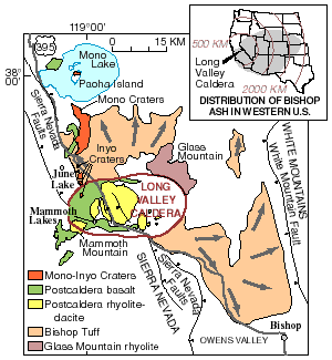
| Description | Geologic map of Long Valley and Mono Basin region | |||
| Date | ||||
| Source | Archived source link | |||
| Auteur | United States Geological Survey | |||
| Autorisation (Réutilisation de ce fichier) |
|
Historique du fichier
Cliquer sur une date et heure pour voir le fichier tel qu'il était à ce moment-là.
| Date et heure | Vignette | Dimensions | Utilisateur | Commentaire | |
|---|---|---|---|---|---|
| actuel | 20 mars 2011 à 06:31 | | 300 × 325 (10 kio) | Hike395 | higher resolution original |
| 31 janvier 2010 à 20:31 |  | 250 × 272 (25 kio) | Mav | {{Information |Description=Geologic map of Long Valley and Mono Basin region |Source={{cite web|url=http://volcanoes.usgs.gov/lvo/about/history.php|title=Geologic History of the Long Valley Caldera and Mono-Inyo Craters Volcanic Chain|publisher=United Sta |
Utilisation du fichier
La page suivante utilise ce fichier :
Usage global du fichier
Les autres wikis suivants utilisent ce fichier :
- Utilisation sur en.wikipedia.org
.png)