
Fichier:Franz Josef Land, Aug 2011.jpg
Fichier d’origine (2 400 × 1 800 pixels, taille du fichier : 812 kio, type MIME : image/jpeg)
Ce fichier et sa description proviennent de Wikimedia Commons.
Description
| Description |
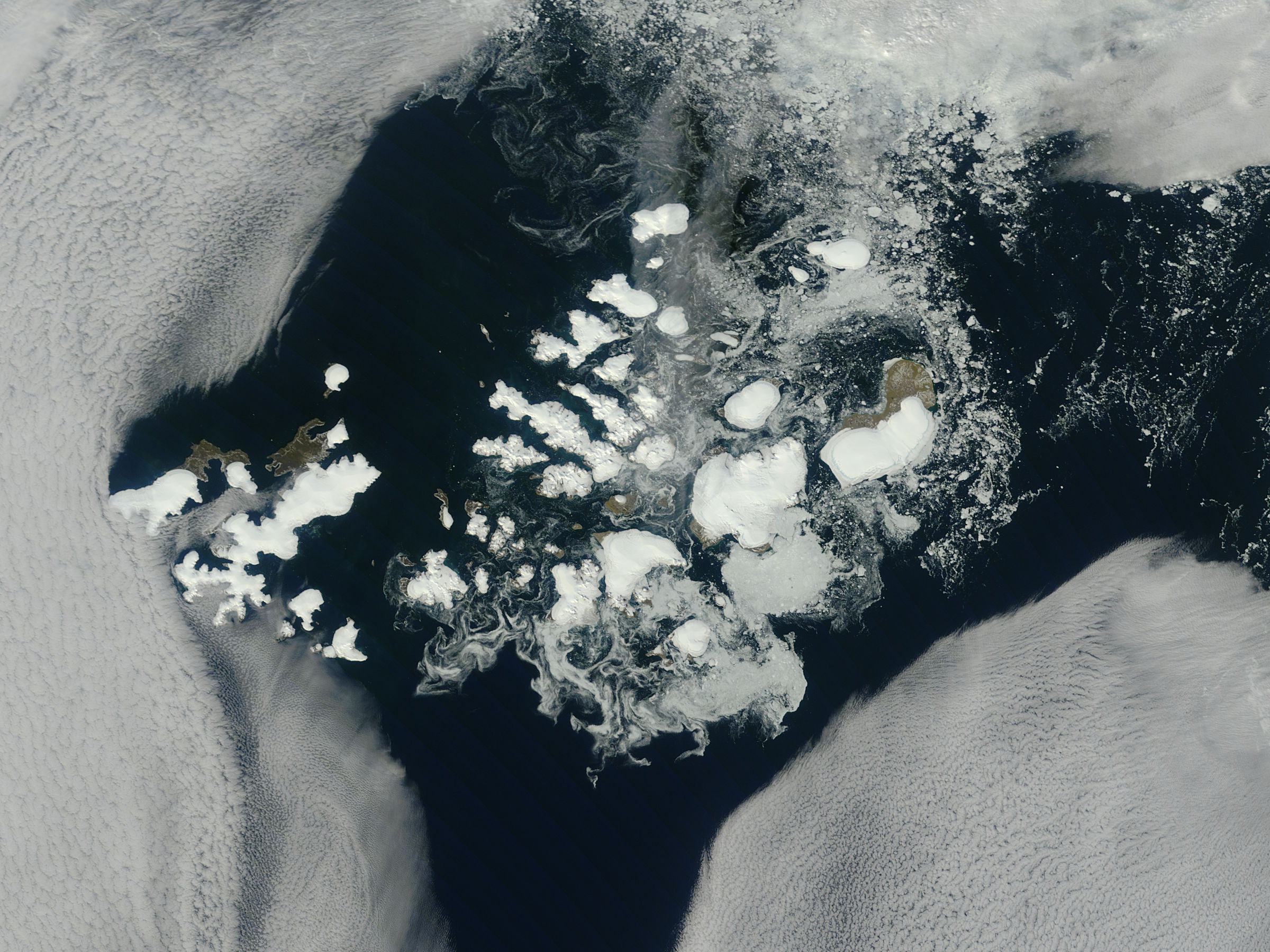
NASA image captured this true-color image on August 14, 2011 The clouds parted over the northeast Barents Sea region of the Arctic Ocean in late summer allowing a view of the ice-covered islands of Franz Josef Land (Russia) forming a stark-white contrast to the surrounding dark sea water. The Moderate Resolution Imaging Spectroradiometer (MODIS) aboard the Terra satellite captured this true-color image on August 14, 2011. Franz Josef Land is an archipelago of 6 main islands and about 135 small islands, with a total landmass of about 16,134 square kilometers (6,229 square miles). The terrain is primarily elevated table lands and low hills, with the highest point rising to 620 m (2034 feet). The glaciers on the islands of Franz Josef are currently in a state of retreat, and in this image large areas of the main islands clearly appear ice free. However, up to 85% of the island’s landmass is permanently ice-covered, with an average ice thickness of about 180 m (590 feet). On Graham Bell Island —the large island on the eastern edge of the group— the Windy Dome Ice Cap reaches a depth of greater than 500 m (1,640 feet). Although being late summer, sea ice can still be seen surrounding many of the islands. Credit: NASA/GSFC/Jeff Schmaltz/MODIS Land Rapid Response Team NASA Goddard Space Flight Center enables NASA’s mission through four scientific endeavors: Earth Science, Heliophysics, Solar System Exploration, and Astrophysics. Goddard plays a leading role in NASA’s accomplishments by contributing compelling scientific knowledge to advance the Agency’s mission. Follow us on Twitter Like us on Facebook Find us on Instagram |
| Date | |
| Source |
Franz Josef Land, Arctic Ocean
|
| Auteur | NASA Goddard Space Flight Center from Greenbelt, MD, USA |
Conditions d’utilisation
| Ce fichier provient de la NASA. Sauf exception, les documents créés par la NASA ne sont pas soumis à copyright. Pour plus d'informations, voir la politique de copyright de la NASA. | ||
 |
Attention :
|
- Vous êtes libre :
- de partager – de copier, distribuer et transmettre cette œuvre
- d’adapter – de modifier cette œuvre
- Sous les conditions suivantes :
- paternité – Vous devez donner les informations appropriées concernant l'auteur, fournir un lien vers la licence et indiquer si des modifications ont été faites. Vous pouvez faire cela par tout moyen raisonnable, mais en aucune façon suggérant que l’auteur vous soutient ou approuve l’utilisation que vous en faites.
| Cette image, qui provient de Flickr, a été vérifiée le August 31, 2011 par l'administrateur ou l'utilisateur de confiance (trusted user) File Upload Bot (Magnus Manske), qui a confirmé qu'à cette date, elle était publiée sur Flickr sous cette licence. |
Historique du fichier
Cliquer sur une date et heure pour voir le fichier tel qu'il était à ce moment-là.
| Date et heure | Vignette | Dimensions | Utilisateur | Commentaire | |
|---|---|---|---|---|---|
| actuel | 31 août 2011 à 23:04 | | 2 400 × 1 800 (812 kio) | File Upload Bot (Magnus Manske) | {{Information |Description=NASA image captured this true-color image on August 14, 2011 The clouds parted over the northeast Barents Sea region of the Arctic Ocean in late summer, 2011 allowing a view of the ice-covered islands of Franz Josef Land, Russi |
Utilisation du fichier
La page suivante utilise ce fichier :
Usage global du fichier
Les autres wikis suivants utilisent ce fichier :
- Utilisation sur af.wikipedia.org
- Utilisation sur ar.wikipedia.org
- Utilisation sur avk.wikipedia.org
- Utilisation sur az.wikipedia.org
- Utilisation sur ba.wikipedia.org
- Utilisation sur ca.wikipedia.org
- Utilisation sur cs.wikipedia.org
- Utilisation sur cv.wikipedia.org
- Utilisation sur da.wikipedia.org
- Utilisation sur de.wikipedia.org
- Utilisation sur el.wikipedia.org
- Utilisation sur en.wikipedia.org
- Utilisation sur lt.wikipedia.org
- Utilisation sur oc.wikipedia.org
- Utilisation sur pl.wikipedia.org
- Utilisation sur ru.wikipedia.org
- Utilisation sur sco.wikipedia.org
- Utilisation sur simple.wikipedia.org
- Utilisation sur vi.wikipedia.org