
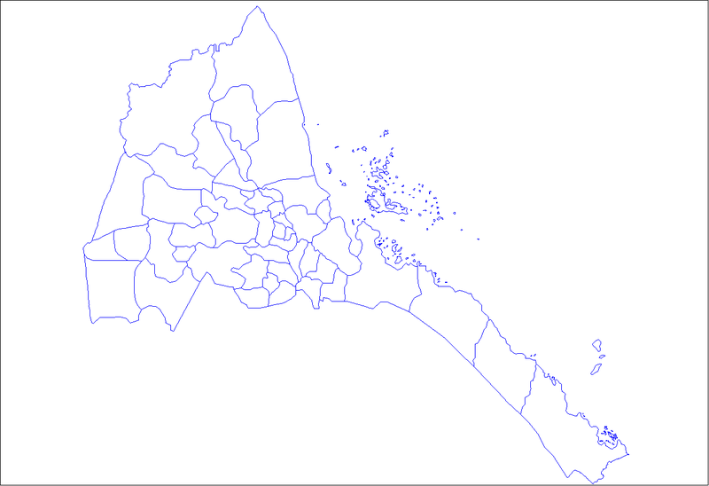
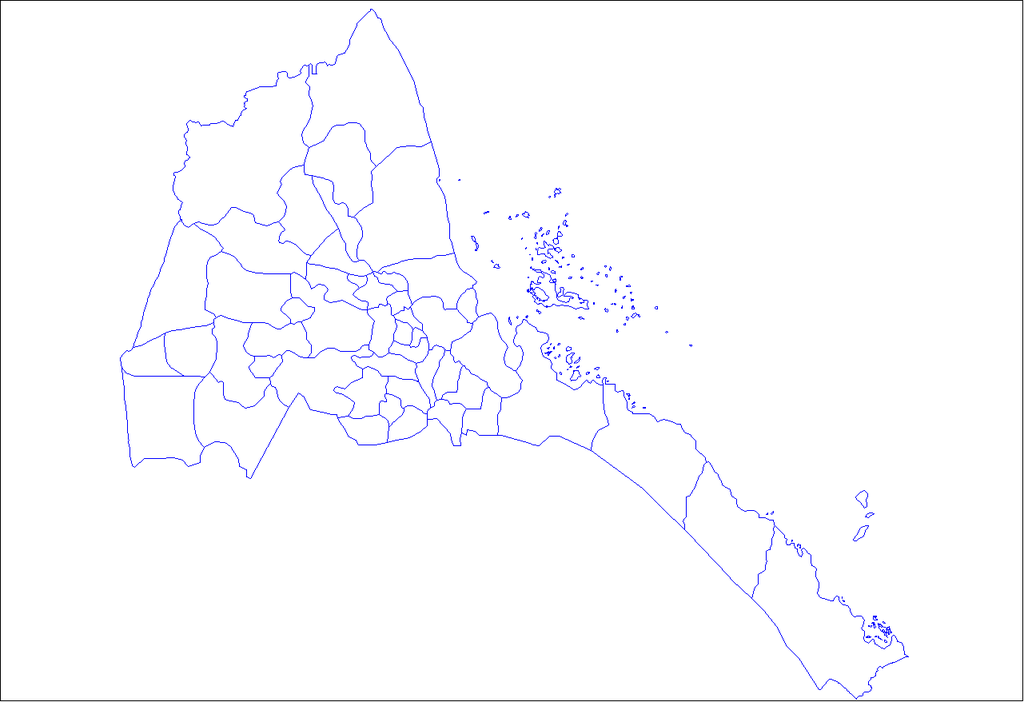
Fichier:Eritrea districts.png

Taille de cet aperçu : 800 × 548 pixels. Autres résolutions : 320 × 219 pixels | 640 × 439 pixels | 1 024 × 702 pixels | 1 281 × 878 pixels.
Fichier d’origine (1 281 × 878 pixels, taille du fichier : 20 kio, type MIME : image/png)
Ce fichier et sa description proviennent de Wikimedia Commons.
Description
| Description | Map of the districts of Eritrea. Created by Rarelibra 19:03, 11 April 2007 (UTC) for public domain use, using MapInfo Professional v8.5 and various mapping resources. |
| Date | 11 avril 2007 (date de téléversement originale) |
| Source | La source n’a pas pu être reconnue automatiquement. « Travail personnel » supposé (étant donné la revendication de droit d’auteur). |
| Auteur | L’auteur n’a pas pu être identifié automatiquement. Il est supposé qu'il s'agit de : Rarelibra (étant donné la revendication de droit d’auteur). |
Conditions d’utilisation
| Moi, propriétaire des droits d’auteur sur cette œuvre, la place dans le domaine public. Ceci s'applique dans le monde entier. Dans certains pays, ceci peut ne pas être possible ; dans ce cas : J’accorde à toute personne le droit d’utiliser cette œuvre dans n’importe quel but, sans aucune condition, sauf celles requises par la loi. |
Historique du fichier
Cliquer sur une date et heure pour voir le fichier tel qu'il était à ce moment-là.
| Date et heure | Vignette | Dimensions | Utilisateur | Commentaire | |
|---|---|---|---|---|---|
| actuel | 11 avril 2007 à 21:03 | | 1 281 × 878 (20 kio) | Rarelibra | Map of the districts of Eritrea. Created by ~~~~ for public domain use, using MapInfo Professional v8.5 and various mapping resources. |
Utilisation du fichier
Les 60 pages suivantes utilisent ce fichier :
- Adi Keyh (district)
- Adi Quala (district)
- Adi Tekelezan (district)
- Afabet (district)
- Akurdet (district)
- Anseba
- Are'eta
- Areza (district)
- Asmat (district)
- Barentu (district)
- Berikh (district)
- Dahlak
- Dbarwa (district)
- Debub
- Debub-Keih-Bahri
- Dekemhare (district)
- Denkalya central
- Denkalya méridional
- Dghe (district)
- District nord-est
- District sud-est
- District sud-ouest
- Elabered (district)
- Foro (district)
- Forto (district)
- Gash-Barka
- Gash supérieur
- Geleb (district)
- Ghala Nefhi (district)
- Ghelalo (district)
- Ghinda (district)
- Gogne (district)
- Habero
- Hagaz (district)
- Halhal (district)
- Haykota (district)
- Karura (district)
- Keren (district)
- Kerkebet (district)
- Kudo Be'ur (district)
- Logo Anseba (district)
- Maekel
- Mai-Mne (district)
- Massaoua (district)
- Mendefera (district)
- Mensura (district)
- Mogolo (district)
- Molki
- Nakfa (district)
- Omhajer (district)
- Segeneiti (district)
- Sela (district)
- Semien-Keih-Bahri
- Senafe (district)
- Serejaka
- Shambuko (district)
- She'eb (district)
- Subdivisions de l'Érythrée
- Tesseney (district)
- Modèle:Palette Subdivisions de l'Érythrée
Usage global du fichier
Les autres wikis suivants utilisent ce fichier :
- Utilisation sur ar.wikipedia.org
- Utilisation sur en.wikipedia.org
- Subregions of Eritrea
- User talk:Markussep/Archive 4
- Template:Districts of Eritrea
- Adi Tekelezan Subregion
- Asmat Subregion
- Elabered Subregion
- Geleb Subregion
- Hagaz Subregion
- Halhal Subregion
- Habero Subregion
- Keren Subregion
- Kerkebet Subregion
- Sela Subregion
- Berikh Subregion
- Ghala Nefhi Subregion
- North Eastern Subregion
- Serejaka Subregion
- South Eastern Subregion
- South Western Subregion
- Akurdet Subregion
- Dghe Subregion
- Gogne Subregion
- Barentu Subregion
- Forto Subregion
- Haykota Subregion
- Logo Anseba Subregion
- Mensura Subregion
- Mogolo Subregion
- Shambuko Subregion
- Molki Subregion
- Teseney Subregion
- Omhajer Subregion
- Upper Gash Subregion
- Afabet Subregion
- Dahlak Subregion
- Ghela'elo Subregion
- Foro Subregion
- Ghinda Subregion
- Karura Subregion
- Massawa Subregion
- She'eb Subregion
- Adi Keyh Subregion
- Adi Quala Subregion
- Areza Subregion
- Debarwa Subregion
- Dekemhare Subregion
- Kudo Be'ur Subregion
- Mai-Mne Subregion
- Mendefera Subregion
Voir davantage sur l’utilisation globale de ce fichier.