
Fichier:Entrance to Beeston Lock - geograph.org.uk - 52633.jpg
Pas de plus haute résolution disponible.
Entrance_to_Beeston_Lock_-_geograph.org.uk_-_52633.jpg (640 × 427 pixels, taille du fichier : 112 kio, type MIME : image/jpeg)
Ce fichier et sa description proviennent de Wikimedia Commons.
Description
| Description |
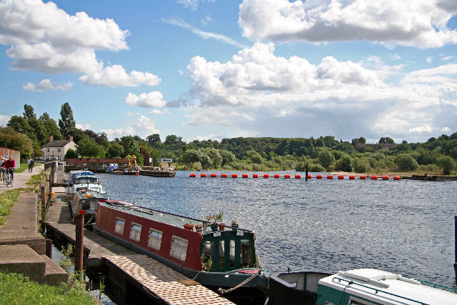
English: Entrance to Beeston Lock. Just after Beeston Marina, from where this photo was taken, the River Trent flows over Beeston Weir, forcing boats through Beeston Lock and along Beeston Canal if they wish to continue towards Nottingham. The view shows the float barrier which stops boats going over the weir in the centre of the picture. The entrance to Beeston Lock is towards the left - the lock itself is just in front of the white-washed lock-keeper's cottage. The canal towpath is very popular with cyclists, walkers and joggers, and provides a welcome break at lunchtimes for workers on nearby industrial sites. |
| Date | |
| Source | From geograph.org.uk |
| Auteur | Christine Hasman |
| Attribution (imposé par la licence) | Christine Hasman / Entrance to Beeston Lock / |
| Lieu de la prise de vue | | Voir cet endroit et d’autres images sur : OpenStreetMap |
|---|
_region:GB-ENG_heading:112.00&language=fr)
| Position de l'objet | | Voir cet endroit et d’autres images sur : OpenStreetMap |
|---|
_region:GB-ENG_heading:112.00&language=fr)
Conditions d’utilisation

|
Cette image provient de la collection du projet Geograph British Isles. Pour obtenir les coordonnées du photographe, veuillez consulter cette page de description de l'image sur le site du projet. Les droits d'auteurs sur cette image sont détenus par Christine Hasman ; l'image est placée sous une licence Creative Commons avec mention de paternité et partage à l'identique (CC-By-SA) en version 2.0.
|
Ce fichier est disponible selon les termes de la licence Creative Commons Attribution – Partage dans les Mêmes Conditions 2.0 Générique
Attribution: Christine Hasman
- Vous êtes libre :
- de partager – de copier, distribuer et transmettre cette œuvre
- d’adapter – de modifier cette œuvre
- Sous les conditions suivantes :
- paternité – Vous devez donner les informations appropriées concernant l'auteur, fournir un lien vers la licence et indiquer si des modifications ont été faites. Vous pouvez faire cela par tout moyen raisonnable, mais en aucune façon suggérant que l’auteur vous soutient ou approuve l’utilisation que vous en faites.
- partage à l’identique – Si vous modifiez, transformez, ou vous basez sur cette œuvre, vous devez distribuer votre contribution sous la même licence ou une licence compatible avec celle de l’original.
Historique du fichier
Cliquer sur une date et heure pour voir le fichier tel qu'il était à ce moment-là.
| Date et heure | Vignette | Dimensions | Utilisateur | Commentaire | |
|---|---|---|---|---|---|
| actuel | 30 janvier 2010 à 16:38 | | 640 × 427 (112 kio) | GeographBot | == {{int:filedesc}} == {{Information |description={{en|1=Entrance to Beeston Lock. Just after Beeston Marina, from where this photo was taken, the River Trent flows over Beeston Weir, forcing boats through Beeston Lock and along Beeston Canal if they wish |
Utilisation du fichier
La page suivante utilise ce fichier :
Usage global du fichier
Les autres wikis suivants utilisent ce fichier :
- Utilisation sur en.wikipedia.org