
Fichier:Disturnell & Schroeter Map Illustrating the Disputed Boundary Between the United States and Mexico 1853 UTA.jpg

Taille de cet aperçu : 800 × 468 pixels. Autres résolutions : 320 × 187 pixels | 640 × 375 pixels | 1 024 × 599 pixels | 1 280 × 749 pixels | 2 560 × 1 498 pixels | 4 188 × 2 451 pixels.
Fichier d’origine (4 188 × 2 451 pixels, taille du fichier : 1,24 Mio, type MIME : image/jpeg)
Ce fichier et sa description proviennent de Wikimedia Commons.
Description
| Titre |
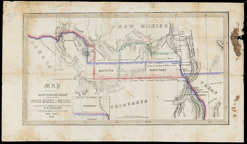
English: Map illustrating the Disputed Boundary between the United States and Mexico |
||||||||||||||||||||||||||
| Description |
English: Soon after the U.S. and Mexican Boundary Commissions began their surveys in 1849, they noted glaring errors on the 1847 map that had been used to negotiate the Treaty of Guadalupe Hidalgo. The town of El Paso, and thus the boundary itself, had been situated too far to the north on the map, resulting in disagreements between the United States and Mexican governments over exactly where the boundary should be. The New York publisher of the original treaty map, John Disturnell, later issued this map to correct the earlier errors and to illustrate the disputed boundary lines that had resulted (the red for the U.S. claim and the blue for Mexico's). Also, as shown, Americans had learned that even with the corrections in latitude, one of the best routes to California – Cooke's Wagon Road – actually lay south of the new border, and a large lobby of U.S. citizens wanted the land to construct a railroad from El Paso to the Pacific. Given the Mexican government's need for cash, on December 30, 1853, U.S. and Mexican diplomats signed the Gadsden Purchase treaty, whereby the United States paid Mexico $10 million for 29,142,400 acres of a wedge of land within the present states of New Mexico and Arizona. |
||||||||||||||||||||||||||
| Date | |||||||||||||||||||||||||||
| Source | UTA Libraries Cartographic Connections: carte / texte | ||||||||||||||||||||||||||
| Créé par |
|
||||||||||||||||||||||||||
| Attribution de l’acquisition |
English: UTA Libraries Special Collections |
||||||||||||||||||||||||||
| Données géotemporelles | |||||||||||||||||||||||||||
| Lieu |
États-Unis Mexique |
||||||||||||||||||||||||||
| Géoréférencement | Si c'est inapproprié, définissez warp_status = skip pour masquer. | ||||||||||||||||||||||||||
| Données bibliographiques | |||||||||||||||||||||||||||
| Lieu de publication | New York | ||||||||||||||||||||||||||
| Imprimé par |
|
||||||||||||||||||||||||||
| Données d'archives | |||||||||||||||||||||||||||
| Collection |
|
||||||||||||||||||||||||||
| Dimensions | hauteur : 22,5 cm ; largeur : 40 cm | ||||||||||||||||||||||||||
| Technique / matériaux | lithographie colorée | ||||||||||||||||||||||||||
| artwork-references | Wheat Mapping the Trans-Mississippi West, 3, nº779 , pp. 236, 325 | ||||||||||||||||||||||||||
Conditions d’utilisation

|
This file was provided to Wikimedia Commons by the University of Texas at Arlington Libraries as part of a cooperation project. The University of Texas at Arlington Libraries is part of the University of Texas at Arlington, a public research university located in Arlington, Texas.
|
|
L’auteur est mort en 1877 ; cette œuvre est donc également dans le domaine public dans tous les pays pour lesquels le droit d’auteur a une durée de vie de 100 ans ou moins après la mort de l’auteur. Cette œuvre est dans le domaine public aux États-Unis car elle a été publiée avant le 1er janvier 1929. | |
| Ce fichier a été identifié comme étant exempt de restrictions connues liées au droit d’auteur, y compris tous les droits connexes et voisins. | |
Historique du fichier
Cliquer sur une date et heure pour voir le fichier tel qu'il était à ce moment-là.
| Date et heure | Vignette | Dimensions | Utilisateur | Commentaire | |
|---|---|---|---|---|---|
| actuel | 12 mars 2022 à 20:50 | | 4 188 × 2 451 (1,24 Mio) | Michael Barera | == {{int:filedesc}} == {{Map |title = {{en|'''''Map illustrating the Disputed Boundary between the United States and Mexico'''''}} |description = {{en|Soon after the U.S. and Mexican Boundary Commissions began their surveys in 1849, they noted glaring errors on the 1847 map that had been used to negotiate the Treaty of Guadalupe Hidalgo. The town of El Paso, and thus the boundary itself, had been situated too far to the north on the map, resulting in disagreements between... |
Utilisation du fichier
La page suivante utilise ce fichier :
Usage global du fichier
Les autres wikis suivants utilisent ce fichier :
- Utilisation sur de.wikipedia.org
- Utilisation sur es.wikipedia.org
- Utilisation sur hu.wikipedia.org
- Utilisation sur ko.wikipedia.org