
Fichier:CharlestownSC1780.jpg

Taille de cet aperçu : 800 × 548 pixels. Autres résolutions : 320 × 219 pixels | 640 × 438 pixels | 1 024 × 701 pixels | 1 280 × 877 pixels | 1 967 × 1 347 pixels.
Fichier d’origine (1 967 × 1 347 pixels, taille du fichier : 859 kio, type MIME : image/jpeg)
Ce fichier et sa description proviennent de Wikimedia Commons.
Description
| Description |
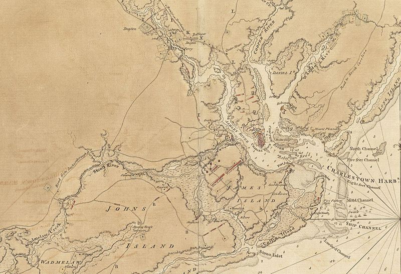
English: This is a detail of the source map, showing the port of Charleston, South Carolina and the coastline to the south as far as Johns Island. It has markings depicting Continental Army defenses set up in anticipation of British attack. The map was probably drawn by British engineers around the time of the 1780 Siege of Charleston. |
||||||
| Date | |||||||
| Source |
From the Boston Public Library Digital Map Collection: http://maps.bpl.org/details_11098/ |
||||||
| Auteur | George Sproule | ||||||
| Autorisation (Réutilisation de ce fichier) |
|


Historique du fichier
Cliquer sur une date et heure pour voir le fichier tel qu'il était à ce moment-là.
| Date et heure | Vignette | Dimensions | Utilisateur | Commentaire | |
|---|---|---|---|---|---|
| actuel | 8 juin 2009 à 15:13 | | 1 967 × 1 347 (859 kio) | Magicpiano | {{Information |Description={{en|1=This is a detail of the source map, showing the port of Charleston, South Carolina and the coastline to the south as far as Johns Island. It has markings depicting Continental Army defenses set up in anticipation of Brit |
Utilisation du fichier
La page suivante utilise ce fichier :
Usage global du fichier
Les autres wikis suivants utilisent ce fichier :
- Utilisation sur ca.wikipedia.org
- Utilisation sur en.wikipedia.org
- Utilisation sur es.wikipedia.org
- Utilisation sur he.wikipedia.org
- Utilisation sur ru.wikipedia.org
- Utilisation sur zh.wikipedia.org