
Fichier:Siedlungsgebiet der Kasachen.png

Taille de cet aperçu : 800 × 494 pixels. Autres résolutions : 320 × 198 pixels | 640 × 395 pixels | 1 024 × 632 pixels | 1 280 × 791 pixels | 1 679 × 1 037 pixels.
Fichier d’origine (1 679 × 1 037 pixels, taille du fichier : 109 kio, type MIME : image/png)
Ce fichier et sa description proviennent de Wikimedia Commons.
Description
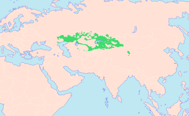
| Description | Darstellungskarte der kasachischen Siedlungsgebiete. Das durchgängig grüne Gebiet stellt das mehrheitlich von Kasachen bewohnte Territorium dar. Die Hauptquellen der Karte sind zum einen Helmut Glück (Hrsg.): Metzler Lexikon Sprache, Karte Türkische Sprachen (S. 782), Verlag J. B. Metzler Stuttgart — Weimar 1993, ISBN 3-476-00937-8 und Willi Stegner: TaschenAtlas Völker und Sprachen, Karte Asien ― Völker (S. 92/93), Klett-Perthes Verlag Gotha — Stuttgart 2006, ISBN 3-12-828123-8 und zum anderen der Putzger Historischer Weltatlas, Karte Die Völker der Sowjetunion (S. 136), Cornelsen Verlag 1991, ISBN 3-46400176-8. Bei der noch weiteren Überarbeitung bzw. Erweiterung der Karte werden die verwendeten Quellen in Form von Webseiten noch angegeben werden. |
| Date | |
| Source | Travail personnel |
| Auteur | Hardcore-Mike |
Conditions d’utilisation
Moi, en tant que détenteur des droits d’auteur sur cette œuvre, je la publie sous les licences suivantes :

|
Vous avez la permission de copier, distribuer et modifier ce document selon les termes de la GNU Free Documentation License version 1.2 ou toute version ultérieure publiée par la Free Software Foundation, sans sections inaltérables, sans texte de première page de couverture et sans texte de dernière page de couverture. Un exemplaire de la licence est inclus dans la section intitulée GNU Free Documentation License. |
Ce fichier est disponible selon les termes de la licence Creative Commons Attribution – Partage dans les Mêmes Conditions 3.0 (non transposée).
- Vous êtes libre :
- de partager – de copier, distribuer et transmettre cette œuvre
- d’adapter – de modifier cette œuvre
- Sous les conditions suivantes :
- paternité – Vous devez donner les informations appropriées concernant l'auteur, fournir un lien vers la licence et indiquer si des modifications ont été faites. Vous pouvez faire cela par tout moyen raisonnable, mais en aucune façon suggérant que l’auteur vous soutient ou approuve l’utilisation que vous en faites.
- partage à l’identique – Si vous modifiez, transformez, ou vous basez sur cette œuvre, vous devez distribuer votre contribution sous la même licence ou une licence compatible avec celle de l’original.
Vous pouvez choisir l’une de ces licences.
Historique du fichier
Cliquer sur une date et heure pour voir le fichier tel qu'il était à ce moment-là.
| Date et heure | Vignette | Dimensions | Utilisateur | Commentaire | |
|---|---|---|---|---|---|
| actuel | 4 mai 2021 à 22:52 | | 1 679 × 1 037 (109 kio) | Glennznl | Reverted to version as of 11:11, 26 August 2019 (UTC) Rv sockpuppet work |
| 27 août 2019 à 19:09 |  | 1 679 × 1 037 (71 kio) | LenguaMapa | ?, it is standard to colour minority or non-inhabidated areas in a lighter colour. nothing disruptive. | |
| 26 août 2019 à 13:11 |  | 1 679 × 1 037 (109 kio) | LouisAragon | Rv disruption, restored original content | |
| 22 août 2019 à 14:35 |  | 1 679 × 1 037 (71 kio) | LenguaMapa | Population statistics qz-2019, colouring minority/less-populated areas (of Kazakhstan). | |
| 9 septembre 2018 à 17:59 |  | 1 679 × 1 037 (109 kio) | MicBy67 | Reverted to version as of 10:54, 17 December 2012 (UTC), ohne Quellenangabe. Und die Karakalpaken sind KEINE Kasachen! | |
| 7 septembre 2018 à 01:31 |  | 1 679 × 1 037 (70 kio) | Satoshi Kondo | entspricht nun eher dem stand von 2018 | |
| 17 décembre 2012 à 12:54 |  | 1 679 × 1 037 (109 kio) | MicBy67 | Ergänzung des kasachischen Gebietes nach: "Atlantis Weltatlas" (Harms List Verlag 1984), ISBN 3-88199-141-7, S. 104/105 und Ernst Schwabe: "Atlas Deutsche Geschichte. Römerzeit bis 1914", Reprint-Verlag Leipzig, ISBN 978-3-8262-1940-5, S. 92/93 (jewe... | |
| 16 décembre 2012 à 19:23 |  | 1 679 × 1 037 (109 kio) | MicBy67 | Kleinere Überarbeitungen, unter anderem nach; Putzger Historischer Weltatlas, S. 136. Zweisprachige Gebiete entfernt. | |
| 24 novembre 2012 à 23:34 |  | 1 746 × 1 110 (123 kio) | MicBy67 | {{Information |Description=Darstellungskarte der kasachischen Siedlungsgebiete. Das durchgängig grüne Gebiet stellt das mehrheitlich von Kasachen bewohnte Territorium dar. Das schraffierte Gebiet im Norden symbolisiert das mehrheitlich von Russen und... |
Utilisation du fichier
La page suivante utilise ce fichier :
Usage global du fichier
Les autres wikis suivants utilisent ce fichier :
- Utilisation sur da.wikipedia.org
- Utilisation sur de.wikipedia.org
- Utilisation sur hu.wikipedia.org
- Utilisation sur kk.wikipedia.org
- Utilisation sur ro.wikipedia.org
- Utilisation sur uz.wikipedia.org