
Fichier:Shepherd Map of Ancient Italy, Northern Part.jpg
Fichier d’origine (1 820 × 1 480 pixels, taille du fichier : 1,21 Mio, type MIME : image/jpeg)
Ce fichier et sa description proviennent de Wikimedia Commons.
Description
| Description |
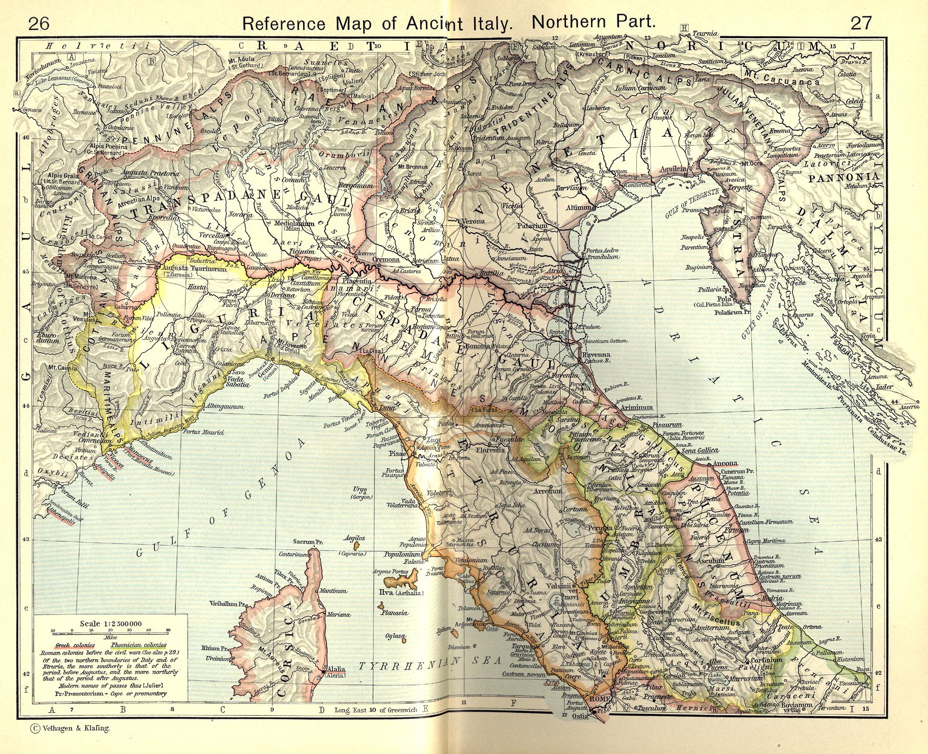
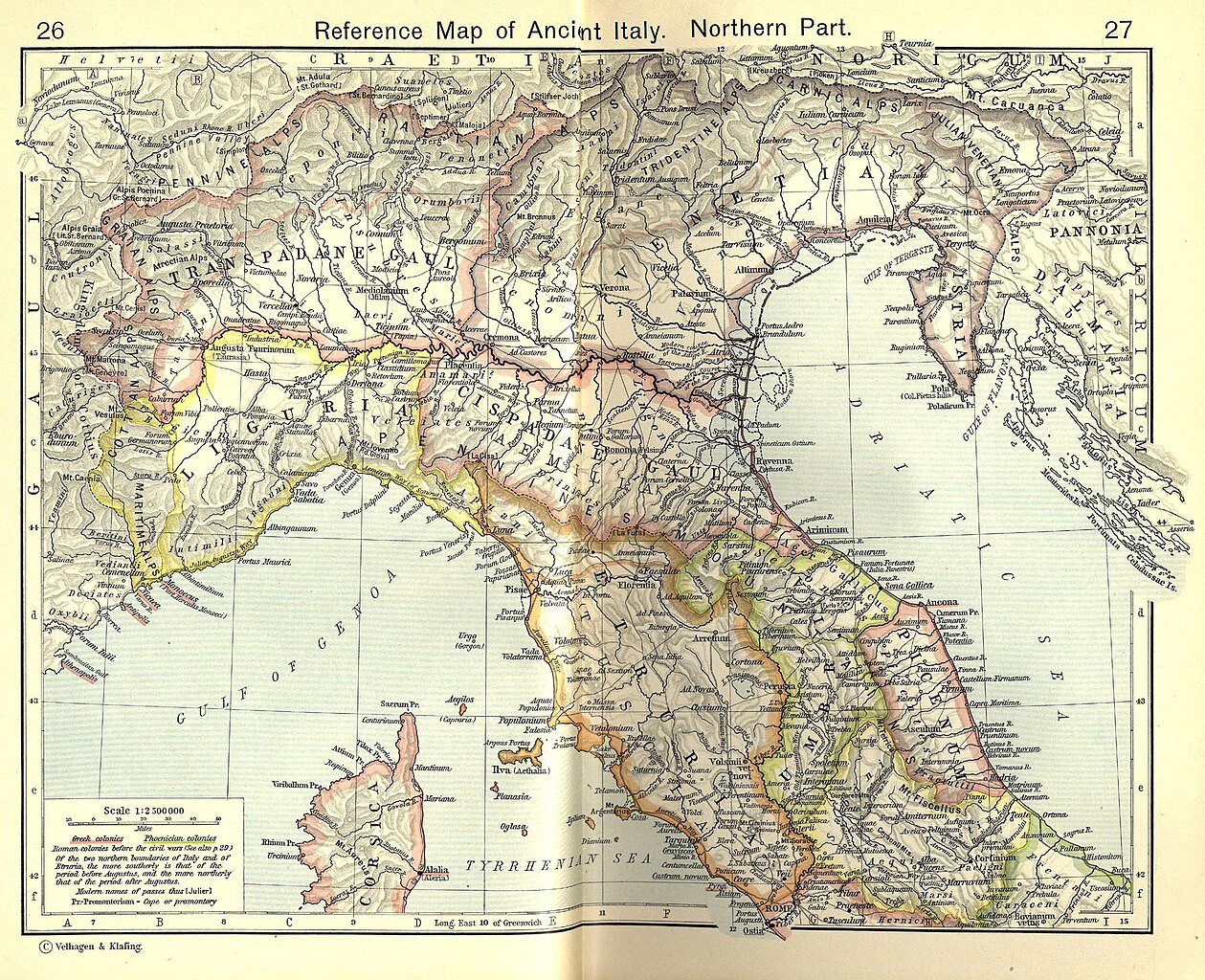
English: Reference Map of Ancient Italy, Northern Part [1]
Historical Atlas by William R. Shepherd, 1911. Courtesy of the University of Texas Libraries, The University of Texas at Austin. From The Historical Atlas by William R. Shepherd, 1911 edition |
| Date | 7 mars 2008 (date de téléversement) |
| Source | Historical Atlas by William R. Shepherd 1911 edition |
| Auteur | Historical Atlas by William R. Shepherd 1911 edition |
| Autorisation (Réutilisation de ce fichier) |
This image is in the public domain due to its age. See also http://www.lib.utexas.edu/usage_statement.html?maps=yes |
| Autres versions | Œuvres dérivées de ce fichier : Ancient Umbria.png |
![[1]](http://www.lib.utexas.edu/maps/historical/shepherd_1911/shepherd-c-026-027.jpg)
Conditions d’utilisation
|
Cette œuvre est également dans le domaine public dans tous les pays pour lesquels le droit d’auteur a une durée de vie de 70 ans ou moins après la mort de l’auteur.
| |
| Ce fichier a été identifié comme étant exempt de restrictions connues liées au droit d’auteur, y compris tous les droits connexes et voisins. | |
Ce document est dans le domaine public aux États-Unis. Ceci s'applique aux travaux des États-Unis où le copyright a expiré, souvent parce que sa première publication s'est produite avant le 1er janvier 1929. Voir cette page pour davantage d'explication.
|
 | |
 |
Cette image peut ne pas être dans le domaine public en dehors des États-Unis (ceci s'applique particulièrement au Canada, en Chine (pas Hong Kong, Macao, ni Taïwan), en Allemagne ou en Suisse). Le créateur et l'année de la publication sont l'information essentielle et doivent être fournis.
|
Historique du fichier
Cliquer sur une date et heure pour voir le fichier tel qu'il était à ce moment-là.
| Date et heure | Vignette | Dimensions | Utilisateur | Commentaire | |
|---|---|---|---|---|---|
| actuel | 19 juillet 2010 à 20:52 | | 1 820 × 1 480 (1,21 Mio) | Cropbot | upload cropped version, operated by User:Beao. Summary: cropped |
| 1 juillet 2007 à 10:02 |  | 1 902 × 1 545 (831 kio) | Accurimbono | == Summary == Map of Northen Italy during the Roman period. Extracted from ''The Historical Atlas'' by William R. Shepherd, 1911. Original image is at http://www.lib.utexas.edu/maps/historical/shepherd_1911/shepherd-c-026-027.jpg [ |
Utilisation du fichier
Les 6 pages suivantes utilisent ce fichier :
Usage global du fichier
Les autres wikis suivants utilisent ce fichier :
- Utilisation sur ast.wikipedia.org
- Utilisation sur bg.wikipedia.org
- Utilisation sur br.wikipedia.org
- Utilisation sur ca.wikipedia.org
- Utilisation sur cs.wikipedia.org
- Utilisation sur de.wikipedia.org
- Utilisation sur en.wikipedia.org
- Utilisation sur es.wikipedia.org
- Utilisation sur et.wikipedia.org
- Utilisation sur it.wikipedia.org
Voir davantage sur l’utilisation globale de ce fichier.